When I first worked in Crawley Down the village was in East Sussex and the local people used to grumble that the postal town, which we were supposed to include in our addresses, was Crawley, in West Sussex. It still is, of course. But it had not always been so, for in the earliest local directories it was noted that letters arrived from and were dispatched to East Grinstead daily. However, those directories make no mention of Crawley Down at all, the residences, such as the Grange, Huntsland and the Duke’s Head, simply being described as in Worth.
Back in the early 1800s people paid to receive letters rather than to post them, a change that did not come in until 1840 with the introduction of the ‘Penny Post’ and the celebrated Penny Black. Before then, a post office was merely the place to which you brought the letters you wanted to send, for them to be collected and taken to the local main post office, which was in East Grinstead. Although there had been one since about 1805 Crawley Down’s first known ‘post office’ was the house called Chandlers, just south of the railway bridge on the Turners Hill Road. It was built in 1834 and, like local post offices to day, served as a shop as well. At that time there was no village to speak of. The railway line had yet be laid, the church and the school had yet to be built and just along the road to the north stretched a few hundred acres of common land (see Crawley Down in 1829). There was a house opposite belonging to a Mr Milligan (see The house before Bankton) and a couple of old cottages behind. The road that passed in front of Chandlers was a turnpike, with a tollgate a hundred yards to the south.
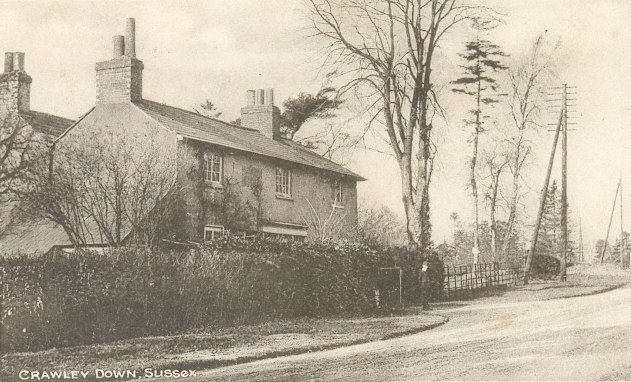
Chandlers, the post office c.1834-1860
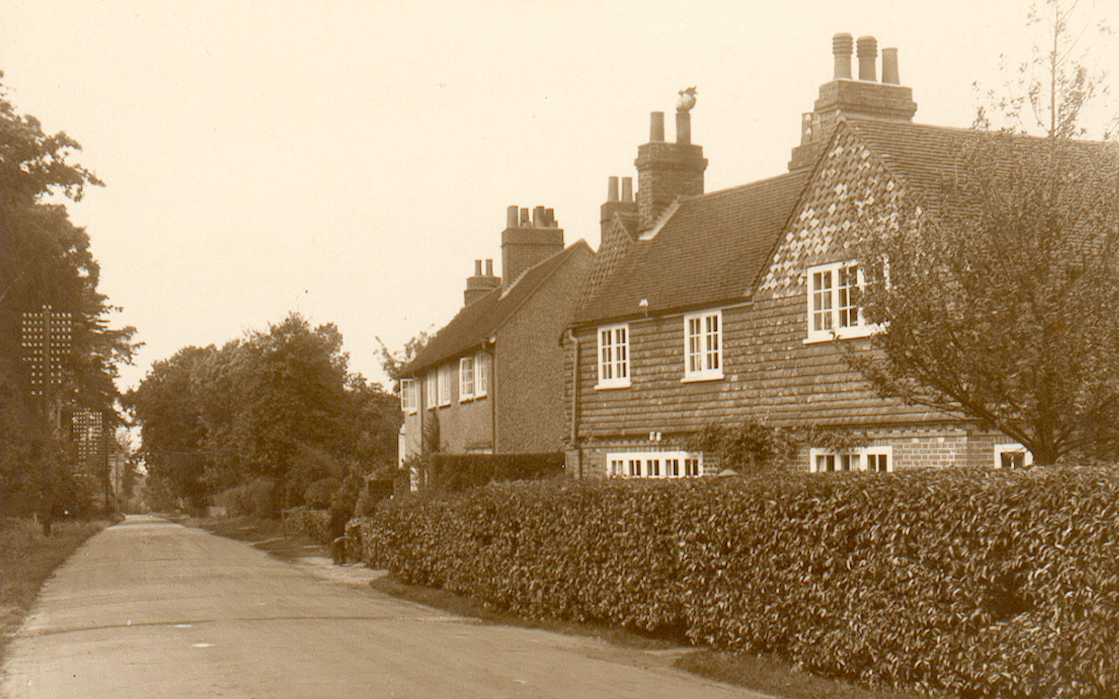
Benjamin Chandler is noted as a ‘letter receiver’ in Melville & Co’s directory in 1858 but in Three Bridges, so perhaps he had opened a shop there; by that date there was a railway station, and perhaps it was considered more appropriate to have a post office nearby. Chandler was still described as a grocer and draper so maybe his shop on the Turners Hill Road remained open. However, in the 1861 census the sub-post master was named as John Brinkhurst, living at ‘Crawley down House’. He was also described as a nurseryman. We can identify this house as what is now called ‘Down Cottage’, and Brinkhurst, still with his nursery, was still there ten years later, and in Kelly’s Directory of 1874 he was named as receiver of letters. John Brinkhurst died later that year, aged 78, and responsibility for the village’s post was taken over by his daughter Mary, while her brother Charles took over the nursery. Mary remained in that role at Down Cottage until at least 1891.
Down Cottage, the post office c.1860-1891
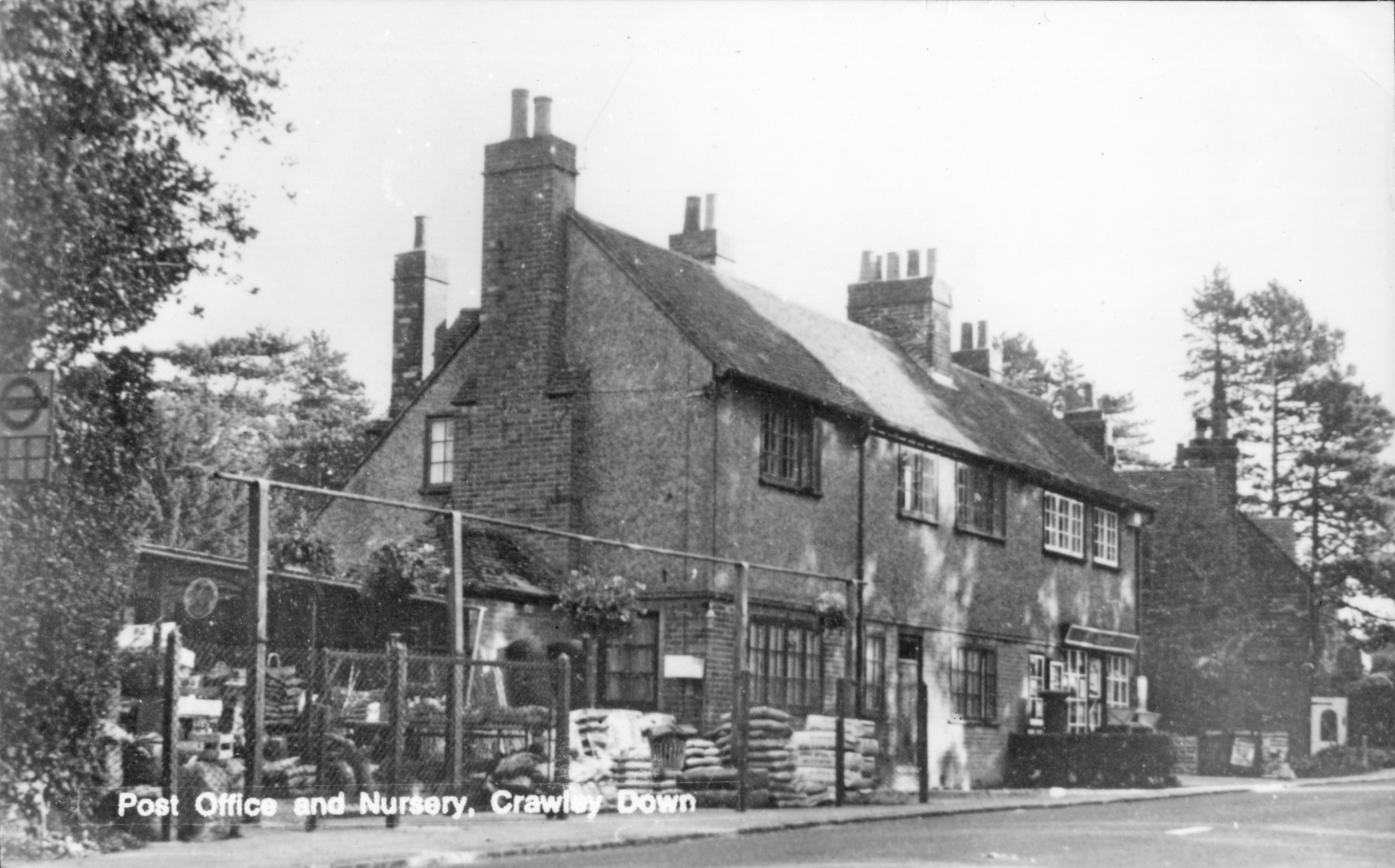
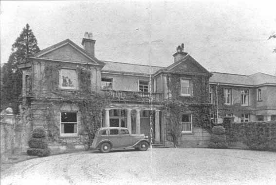
In that year T. H. W.Buckley, who owned The Grange, acquired the neighbouring property and erected a purpose-built post office. Mary Brinkhurst’s nephew Charles took over as post master, while his father continued the nursery business at Down Cottage next door. Mr Buckley became the landlord of the post office until his daughter Edith sold it to Elizabeth Flint in 1931. She sold it to John Potter in 1945 and after he died in 1949 his widow leased it to her sister-in-law, Bertha Potter, for the next 21 years. In 1961 it was sold to R. G. A Richards.
The Post Office 1891-1976
During the early 1970s Crawley Down was growing as a village with the commencement of the Burleighwood Estate, and the centre of the village was shifting to the southern end of the Village Green where there was already a cluster of shops, and where, after the demolition of the railway station a new row of shops was being built that would include a newsagent, greengrocer, estate agent, hairdresser and pharmacy. In 1976 the post office, which had been located near the western end of Sandy Lane for about 120 years, closed and a new one opened where it remains to this day.
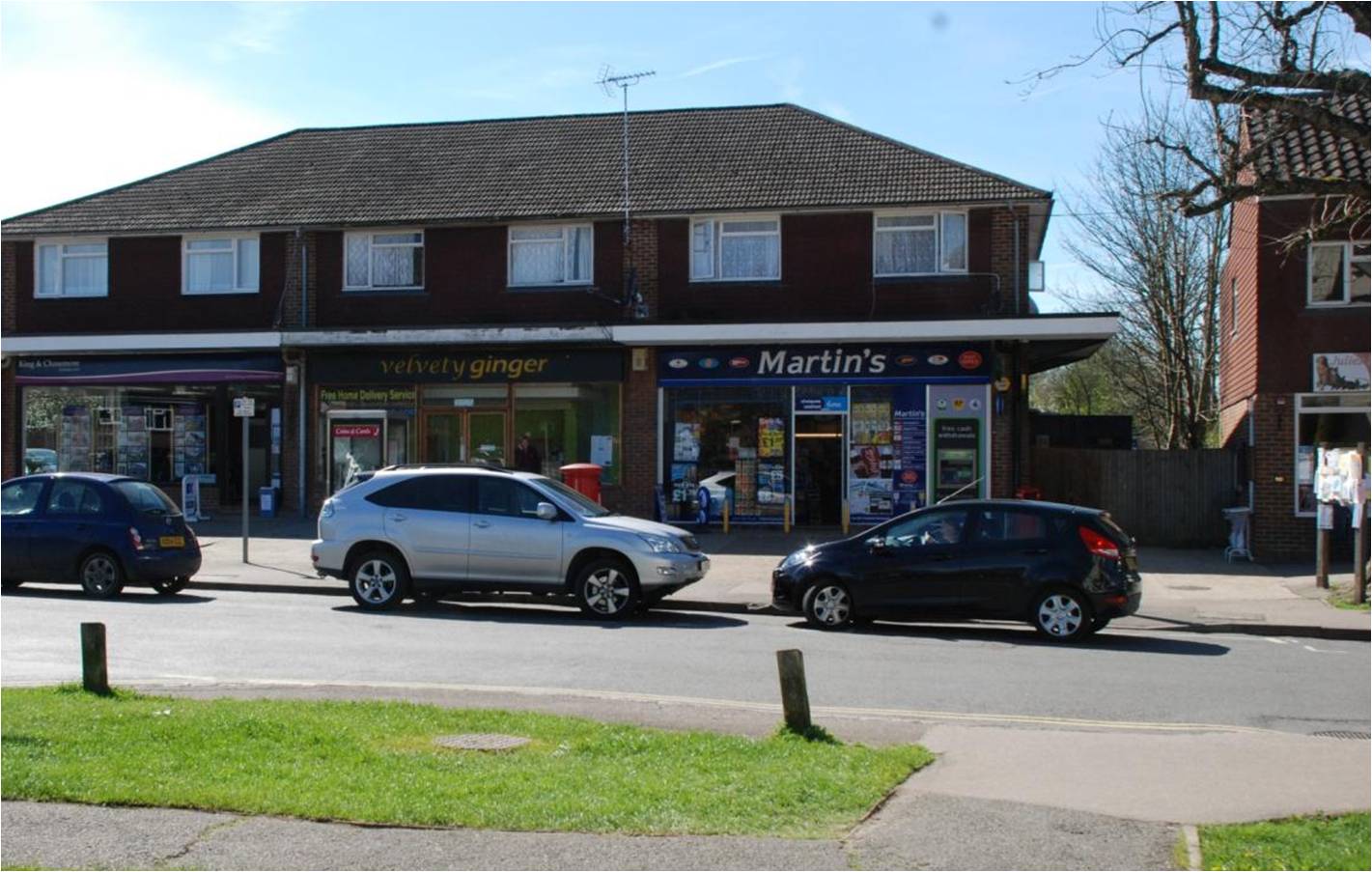
The post office since 1976 – now McColl’s
The old post office has been a private house since 1977.
Back in 1993 All Saints’ Church celebrated its 150th anniversary, and an interesting little booklet, edited by Pamela Petrie, was published at the time which included articles about the history of the church, the village and the school, as well as about different aspects of the church’s role in village life. Some of you may still have a copy.
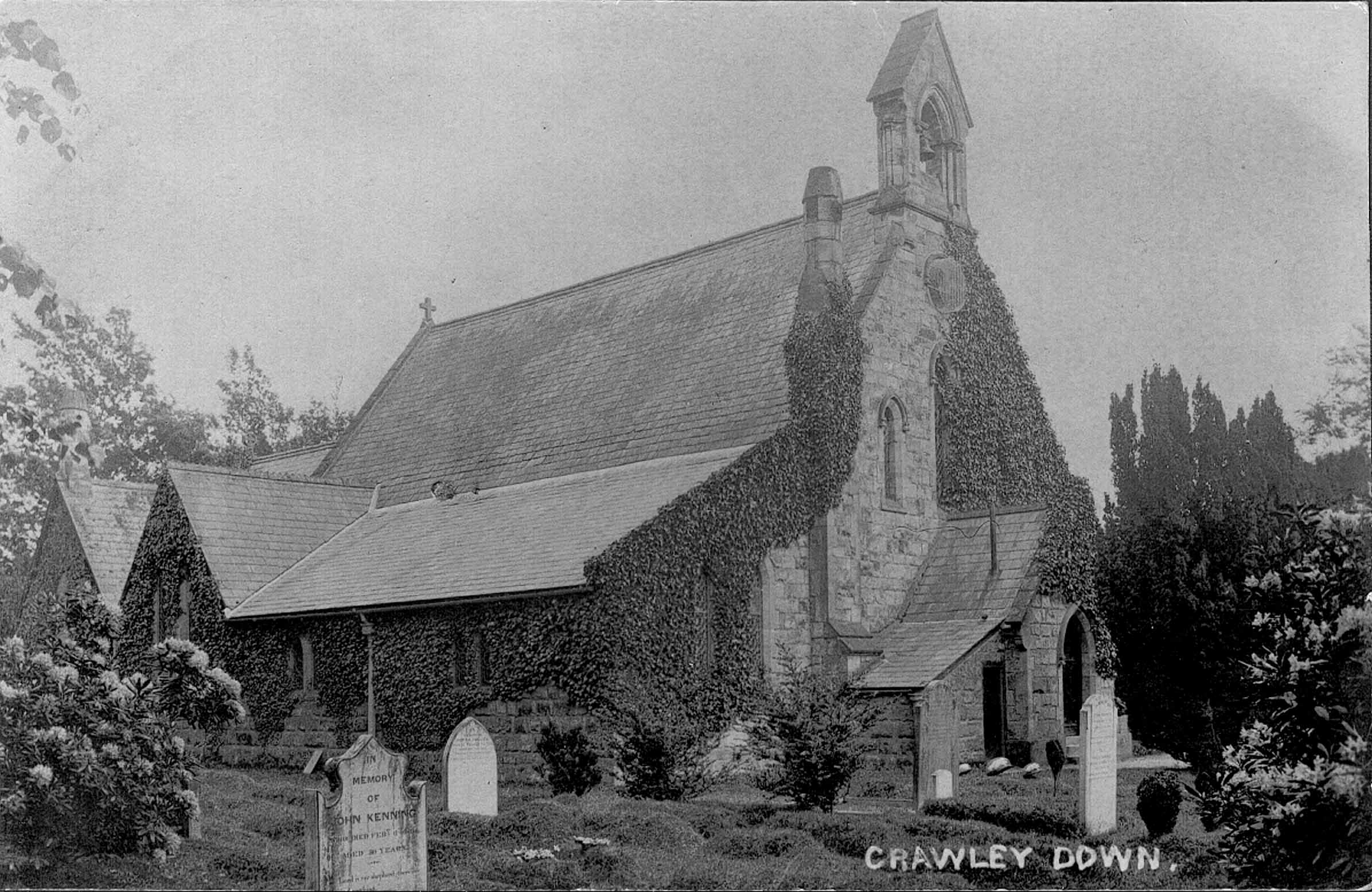
The west end of All Saints’ Church, Crawley Down, at the beginning of the 20th century
Scattered throughout one of the articles are mentions of the infrequent discussions that took place over a period of 40 years about whether a tower ought to be added to the church. Evidently it was first discussed in 1886. The then vicar, the Revd. Steuart-Williams told the Parochial Church Council (PCC) that his late wife had collected 50 guineas (£52.50) and that he would match that if the work could be started during the following 12 months. Plans were drawn up by an architect during the next year and parishioners were asked to subscribe towards the cost. There were also plans to build a south aisle. By 1888 enough had been raised for the aisle, but as only just over £220 had been raised towards the tower it was not enough and the project was put on the back burner.
The proposal was not forgotten, but neither was it pursued with any vigour; a collection of 8 shillings and 5 pence at a service in 1904 was not going to make a difference. The matter was raised again in 1913 but without any result. In 1922, the church funds were running low and the PCC sought to use the interest from the tower fund to carry out some more urgent general repairs, but they were advised that they could not. Then, in 1926 repairs were need to the bellcote above the west end of the church and again permission was sought to divert the tower fund which for reasons not explained then stood at just over £187. An architect was consulted and he stated that a tower would not suit the church as it was then. This time use of the money was allowed and the plan to build a tower came to an end.
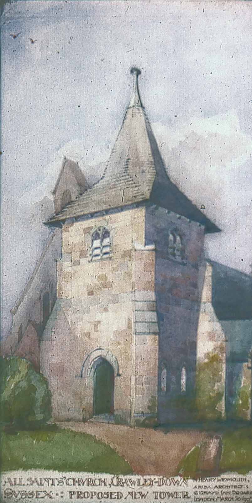
The proposed tower for All Saints’ Church designed by R.H. Weymouth in the 1900s
What is not mentioned in the 1993 booklet, and therefore not in the foregoing account either, is that there must have been another attempt to revive the idea of a tower at the west end of the church, for this watercolour painting survives (I know not where now) of a design for a tower that was made during the first decade of the 20th century. Perhaps it was what prompted the church collection in 1904; perhaps it was what had been discussed in 1913. The architect responsible was R.H. Weymouth who had a practice in Victoria Street, London, and who had been employed at that time by T.H.W. Buckley who owned The Grange to come up with a scheme to develop the Grange estate as a ‘garden village’. Some details of the scheme can be seen in the West Sussex Record Office at Chichester. A few elements were completed, including ‘Ramblers’ (dated 1912) in Turners Hill Road, four or five houses just round the corner at the west end of Sunny Avenue, and a couple of larger ones – ‘Eastnor’ and ‘Gorse Cottage’ – in Vicarage Road, before the outbreak of the First World War put paid to the plan. It would seem likely that this later design for a church tower was part of that scheme, but it is curious that no record seems to have survived among the archives of the church. It is unfortunate that the photograph, which was scanned from a transparency I took back in the 1970s when it belonged to the late George Ryder, is not clear enough to show the date, which can only be deciphered as 190?.
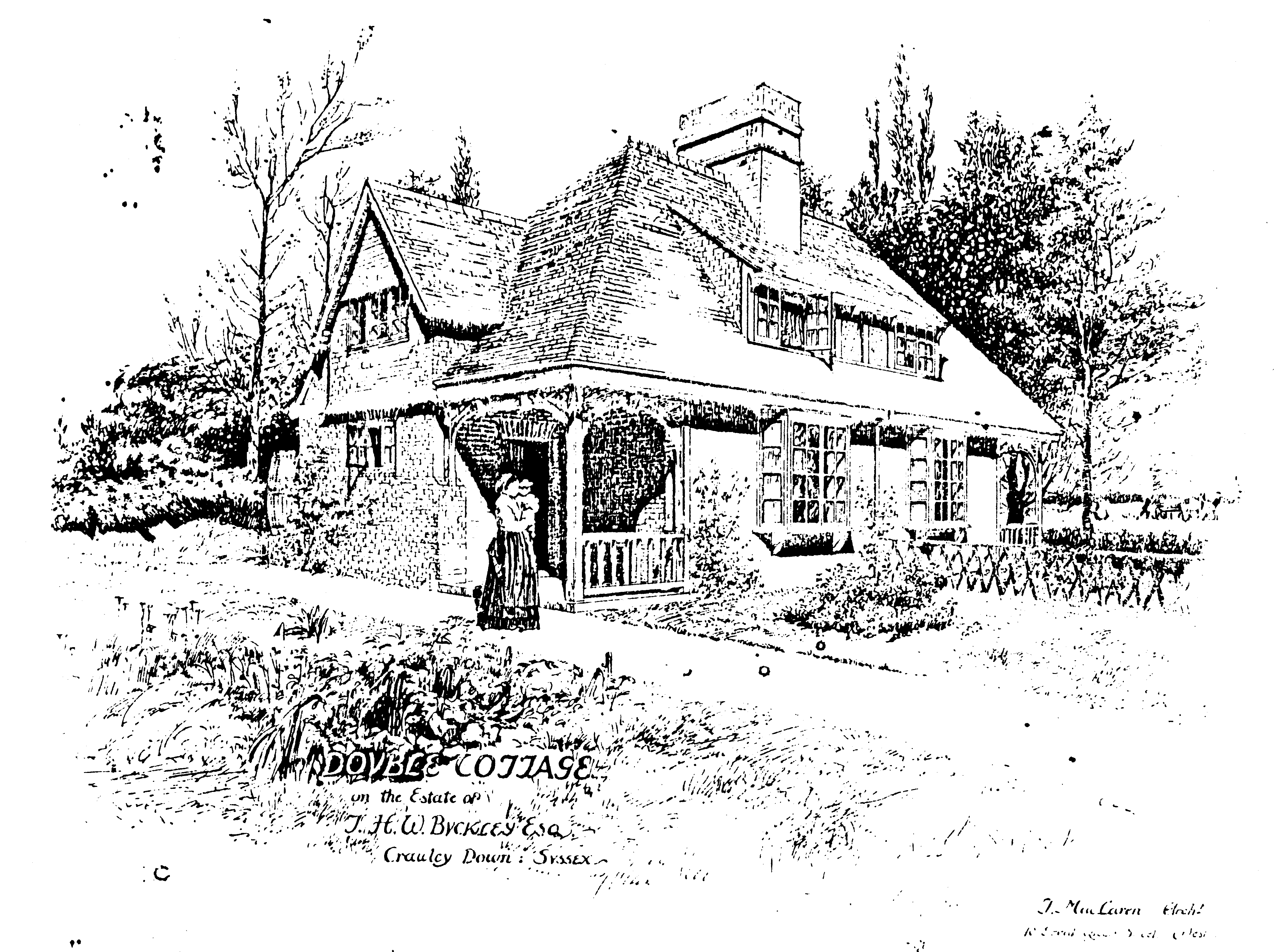
The cottages at Grange Farm designed by Thomas MacLaren in 1898
The name of Thomas MacLaren will probably be unfamiliar to most, if not all, of the readers of this short article, but if you are an inhabitant of Colorado Springs in the USA he will be much better known to you. Born near Callander in Scotland in 1863 he trained as an architect in Edinburgh before moving to London in 1880 and travelling in Europe to further his studies. From 1886 he worked for several architectural practices including that of his brother James. In 1889 he set up on his own in offices in Westminster where his first commission was to design a pair of cottages for The Grange estate belonging to Mr T. H. W. Buckley of Crawley Down. Mr Buckley had inherited The Grange in 1875 on the death of his uncle Richard, but in 1882 had let the house to the Reverend Arthur Meyrick for a school, and had moved with his family to West Hoathly. Continuing as owner of Grange Farm and its land, the cottages Buckley had MacLaren design were for farm workers, adding to an earlier pair of cottages which together with the farmhouse had been built by his uncle.
Thomas MacLaren’s drawing of the Grange Farm cottages
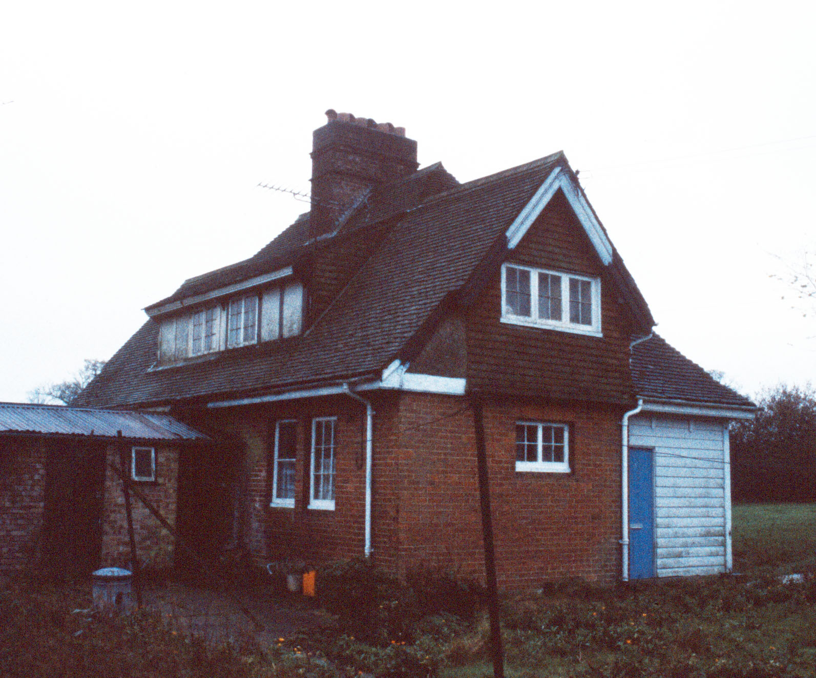
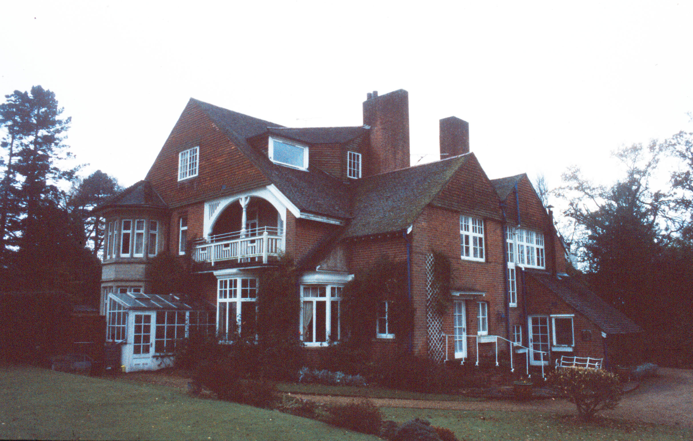
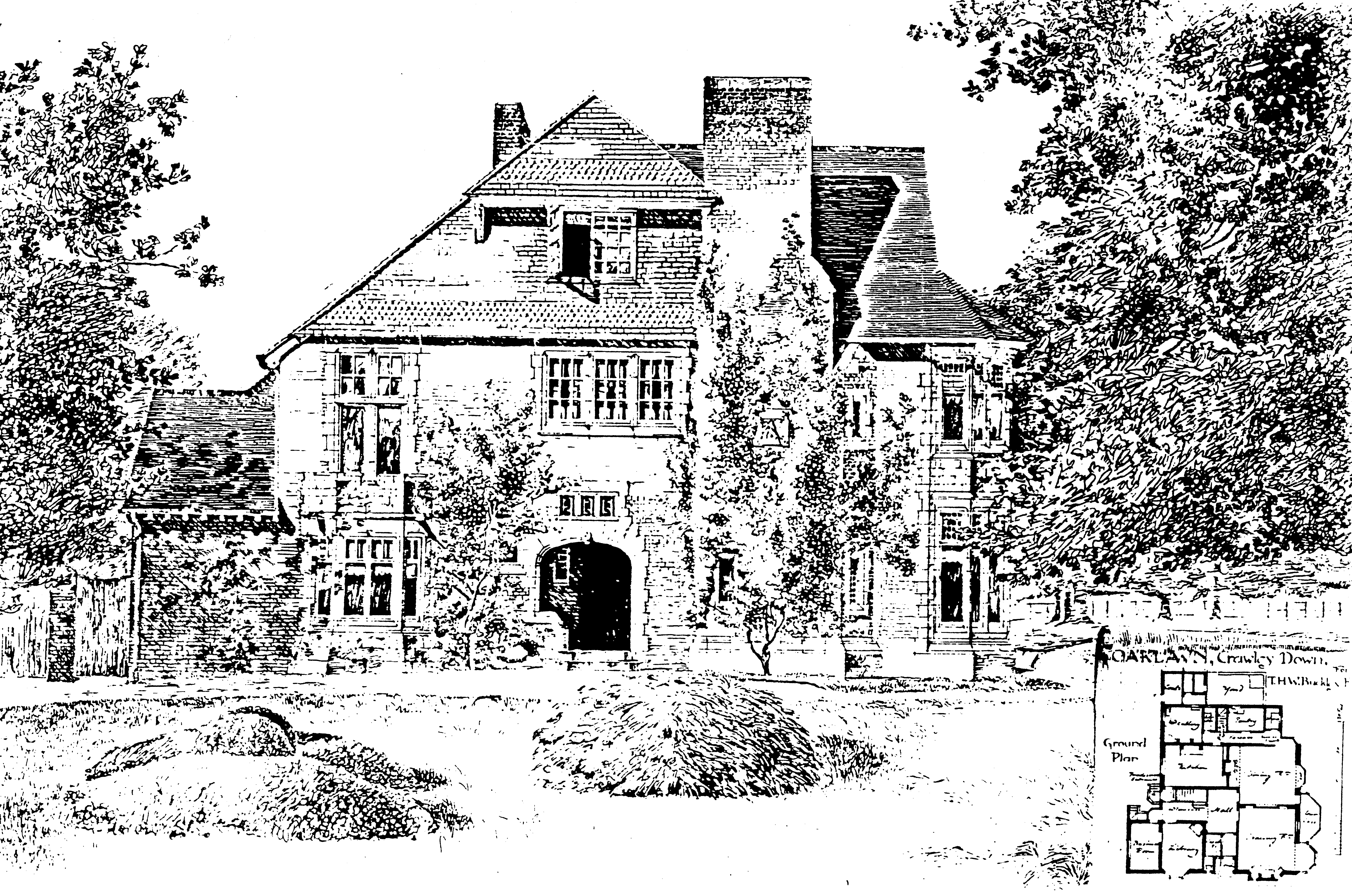
Oaklawn (now Heatherwood) designed by Thomas MacLaren in 1890
Evidently Buckley wanted to return to Crawley Down so following the completion of the cottages he asked MacLaren to design him a house on some land he had owned in Sandy Lane. The result was Oaklawn. MacLaren and his brother had both trained as architects at a time when the Arts and Crafts movement was a strong influence, drawing inspiration from natural forms and locally-sourced materials. The famous Glasgow architect, Charles Rennie Mackintosh, was influenced by the work of James MacLaren. So Oaklawn was inevitably going to reflect the Arts and Crafts ethos. Making use of brick and hung tiles, so typical of houses in the Sussex Weald, it has many features seen on buildings inspired by William Morris’s influence, by architects like Philip Webb, who designed Standen, and later by Edwin Lutyens. According to Kelly’s Directory, the Buckleys were in residence there by 1890, but they had moved back to The Grange nine years later. Nowadays the house is called Heatherwood and is divided into two separate dwellings, and (rather confusingly) the house next door is called Oaklawn instead.
Thomas MacLaren’s drawing of the south front of Oaklawn
Thomas MacLaren also designed a new vicarage at Horne, just over the border in Surrey, but despite only being in his late 20s his health was failing. His brother James had died that year of tuberculosis aged only 37. So after a final commission for some houses in Scotland, Thomas left for the clean air of Switzerland. In 1893 he moved to take advantage of the mountain air of Colorado, where he set up an architectural practice in Colorado Springs, over the next 35 years designing many important municipal buildings and houses there. He died there in 1928.
As the village grew, it was inevitable that some buildings will have been demolished and their sites redeveloped. Sometimes the later developments were given names that recalled what had been there before, such as Hawarden Cottage, which had formerly been called ‘Rushetts’, and stood where now is the top end of Burleigh Way at its junction with Hophurst Lane. It took its name from a village in what used to be Flintshire in North Wales. Crawley Down residents are apt to pronounce the Close which took its name as ‘har-warden’ but the Welsh village is spoken of as ‘harden’. Curiously, the house’s earlier name, ‘Rushetts’, had been the original name for ‘Red Court’, which lies off the east end of Sandy Lane.
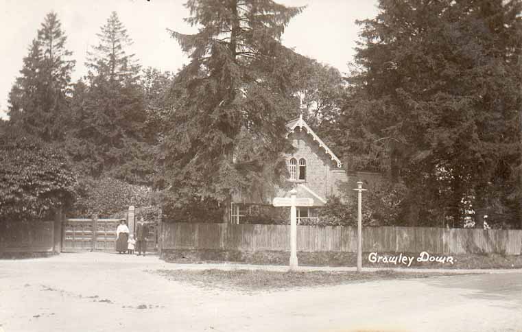
Sunny Lodge, Crawley Down, c.1905
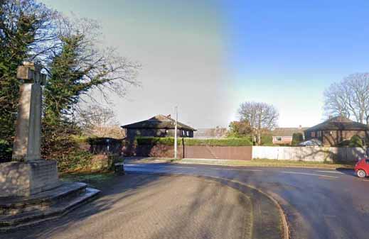
The view nowadays to where Sunny Lodge stood
Pictures of a few of these lost buildings have survived. Opposite the war memorial there used to be Sunny Lodge, at the entrance to the drive to a larger house called Sunnyhill. Both are long gone but a postcard exists of the lodge with its elaborate barge-boards facing its gabled roof. On the opposite side of Sandy Lane two contemporary properties, Sunnyhill Farmhouse and Leigh Wood, sport similar barge-boards, which seem to have been a trademark style of a small number of houses built in the village in the 1870s, probably by the same developer, who may have been Richard Wilson Buckley who had inherited the Grange estate in 1862.
Fermandy Place c. 1950s
A short distance along Hophurst Lane from Sunny Lodge stood Fermandy Place, its name seemingly derived from a French surname. Originally known as ‘Eagle House’, or ‘The Eagles’, it later became ‘The Haven’. When it was sold after the Second World War, as Fermandy Place, its name was changed for the last time, to a preparatory school called Crawley St Mary’s, as some older residents of the village will recall.
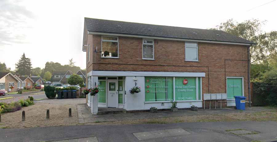
The Dental Care Centre next to Hazelwood Close
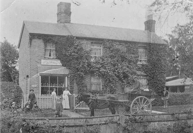
Wilson & Moon, bakers, c.1900
Along the Turners Hill Road, a little to the south of the Village Hall, lies Hazelwood Close on the corner of which is this building, formerly Manning’s the builders but for some time now where dental fittings are made. There was an earlier building on this site, which was a baker’s shop. Back in 1911, it was the home of Frederick Moon, baker and confectioner, and his family. Later it was run by the Holman family.
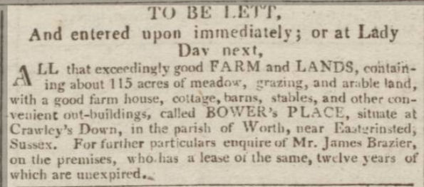
Advertisement of Bower Place Farm to let (Sussex Advertiser, 8 Nov 1813)
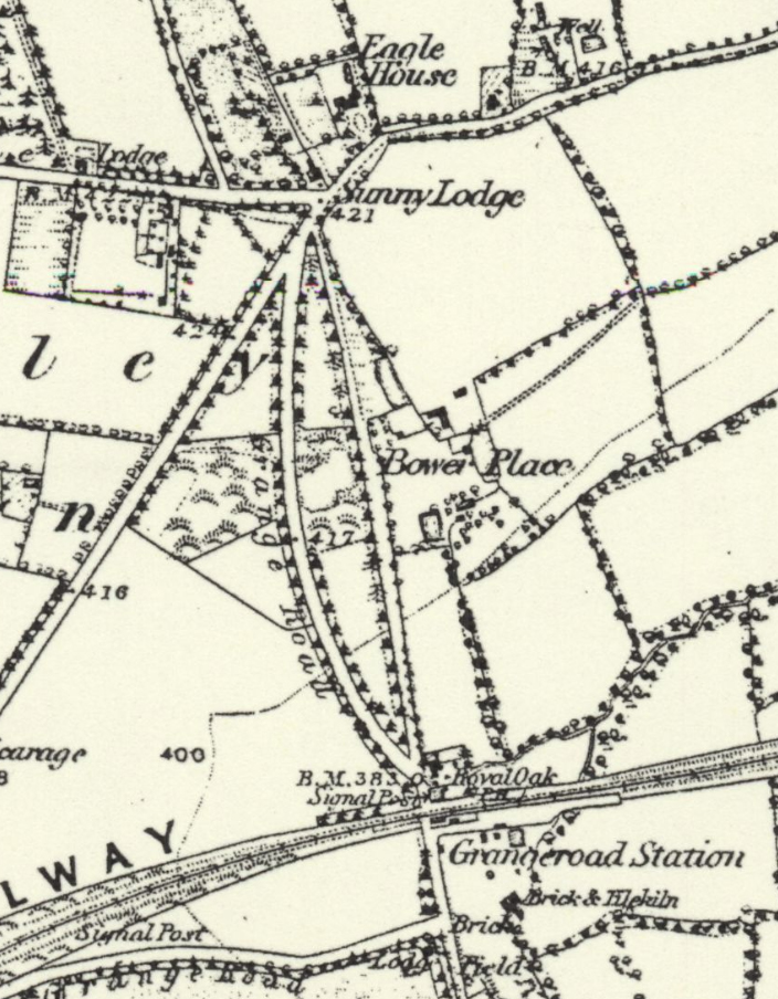
One building of which we have no picture is Bower Place Farm. Before 1890 when the terrace was built which has taken its name, there was a farm set back from the top of the hill. It probably dated back a long time for it occupied land which had been a freehold of the Manor of South Malling-Lindfield when a map was drawn of the manor in 1830, so it would have been considerably older than that. It had been advertised to let in 1813 and was still standing in 1874 when the 1st edition of the Ordnance Survey 6in map was published.
The location of Bower Place Farm (Ordnance Survey 6in. map 1874)
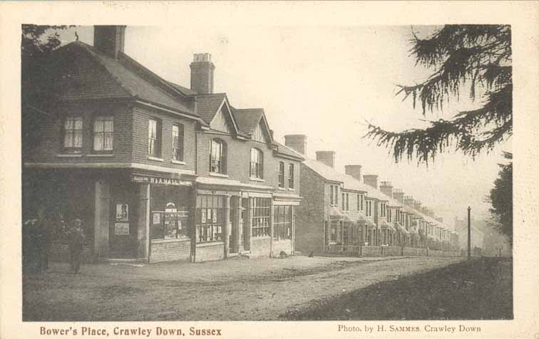
At the beginning of the 20th century Crawley Down was very much a village in two parts, each served by its own group of essential services. Along the Turners Hill Road were the church, the school, the village hall, the post office and a nursery, a general store (now an undertaker) and the baker’s mentioned above. On the other side of the village, north of the railway station, were some other shops at the top and bottom of Bowers Place, including a baker’s and a coal merchant, and a grocer’s at Elm House where the dentist’s is now.
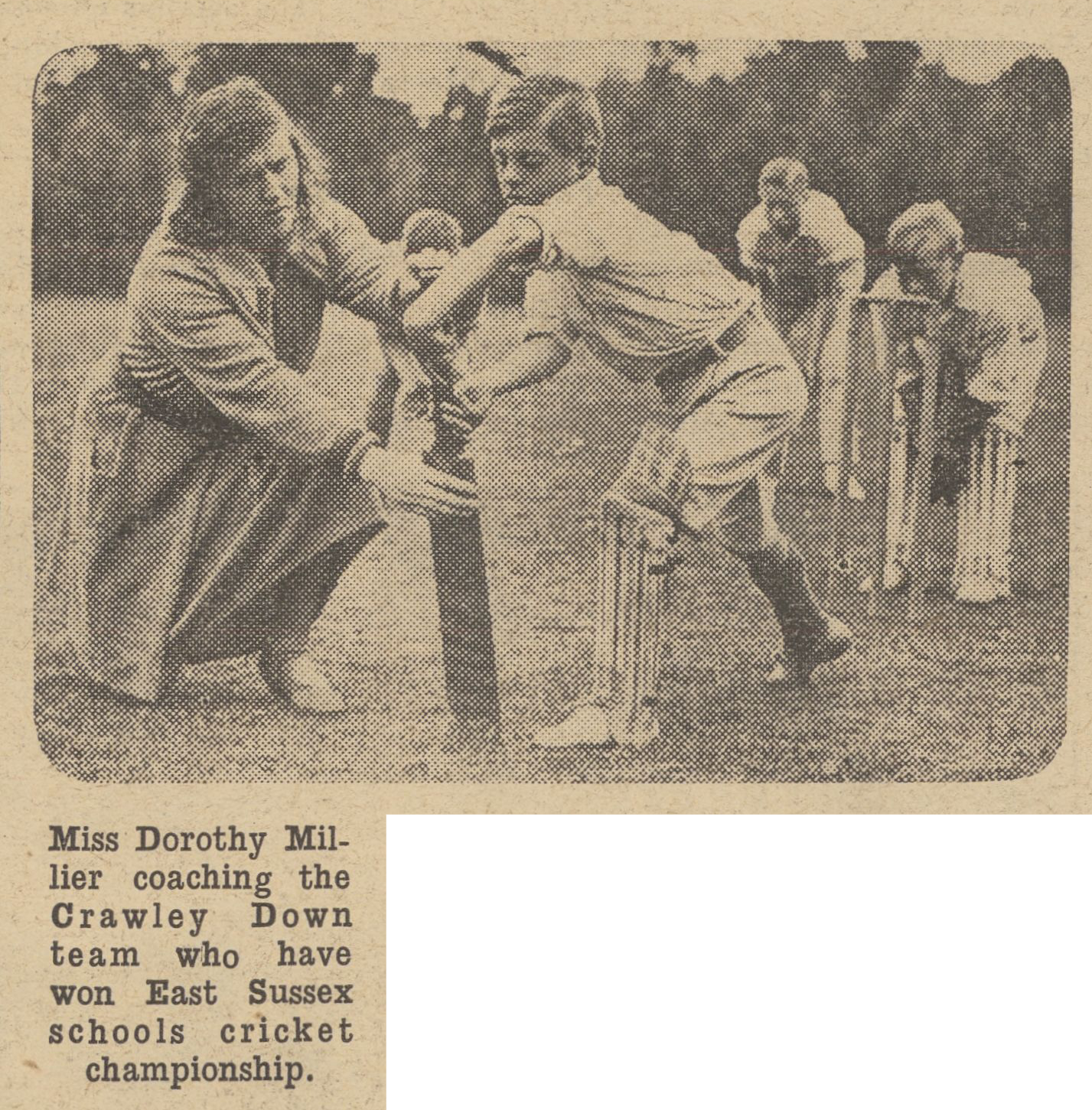
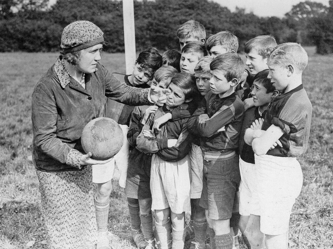
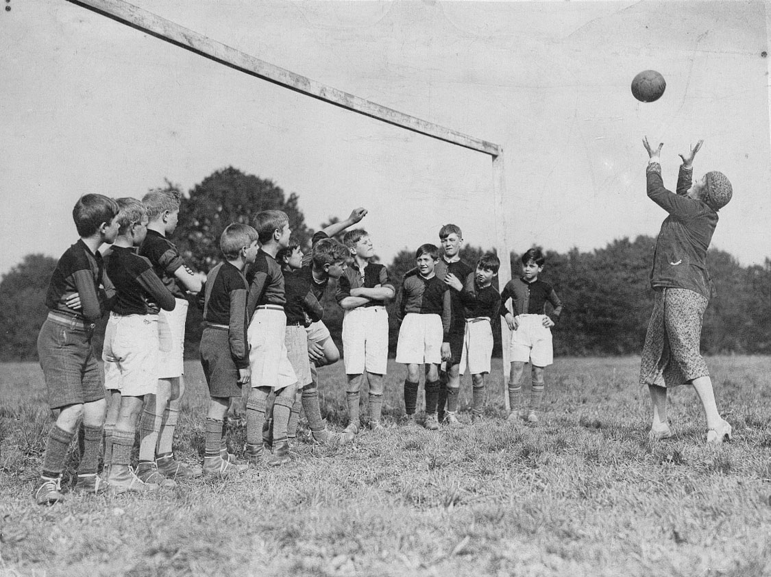
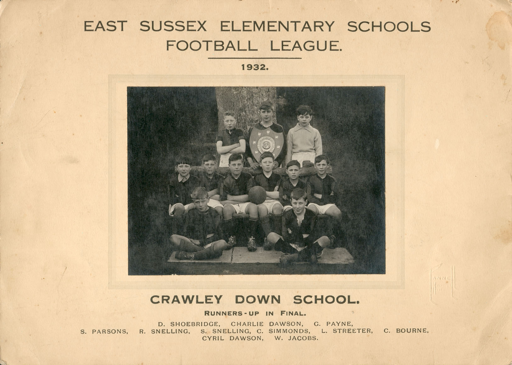
In 1930 Miss Dorothy G. Millier, Lit. Dip., joined the staff of Crawley Down School, I suspect as a temporary Head Teacher. Of her background or life after leaving the school I know absolutely nothing (if anyone does, I will be only too delighted to amend this brief account). All I have are some photographs of the children’s sporting achievements during her reign which I regarded as interesting but not remarkable until I came across this cutting from the Daily Mirror of the 18th July 1931.
It appears that Miss Millier was imbued with a dynamism that raised the standard of sporting prowess among the boys in her charge. I suspect that the staff of the school at the time were all female and that social expectations regarding gender and sport were firmly entrenched. So perhaps it was her apparent disregard of those norms that gained Miss Millier the approval of the national press as well as, I hope, that of her pupils and their parents. She was evidently prepared to practise what she preached, as these photographs show. They were presumably posed for the local press to illustrate her team’s successes at cricket and football in county competitions, and her proactive role in them.
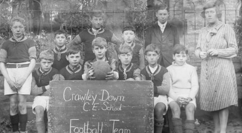
Miss Dorothy Millier with her football team posed beside the churchyard railings in the school playground in 1932
The photographs speak for themselves and maybe there will be readers of this whose grandparents or great-grandparents are among those pictured.
In the year of the Coronation of Queen Elizabeth II, and with the end of the Second World War just eight years in the past, Crawley Down, then in East Sussex, had changed little since the modest building boom that followed the break-up of the Grange Estate in the 1930s. Two triangles of roads made up the main outline of the village: Turners Hill Road and Sandy Lane, Grange Road and Bowers Place/Station Road, and Vicarage Road between them. Hophurst Lane led away to the north-east and Sandhill Lane/Burleigh Lane to the south. Only Sunny Avenue lay between either of those triangles, and of that only the western end had been built.
Crawley Down CE Primary School
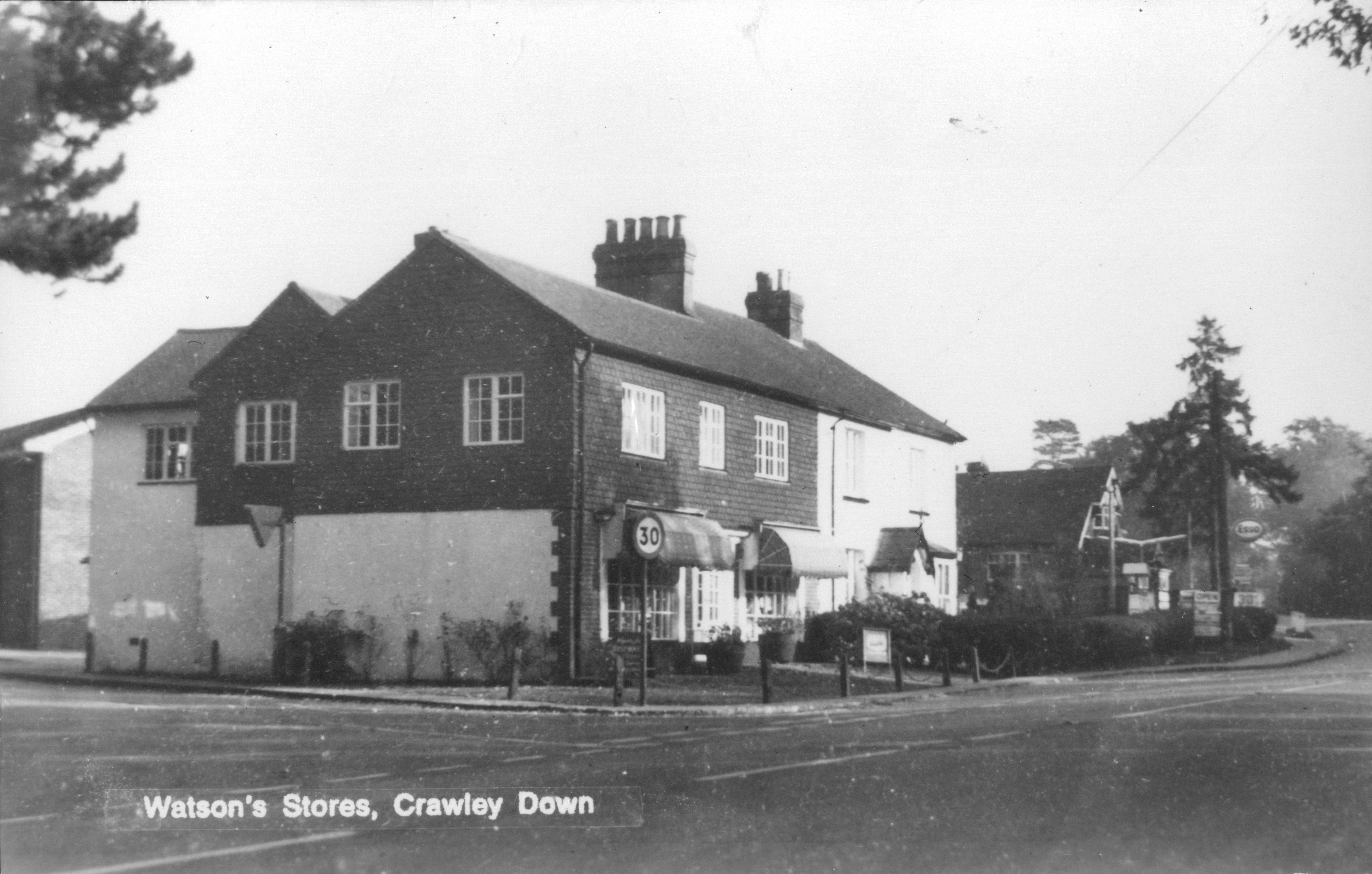
Village institutions still familiar to day were in place, though some were in different locations: All Saints’ Church with its Parish Room, the Village Hall and the Royal Oak. The Post Office was then on the Turners Hill Road, just round the corner from the end of Sandy Lane (seeCrawley Down’s post offices), and the School was next to the church, also along the Turners Hill Road. There were the allotments and the Village Green, the Cricket Ground and King George’s Field, the last of these opened just before the war. There were shops, but not in the places where we have them now. Where the undertakers is now was Watson’s Stores and just along the road, between there and the Village Hall, was Hartley House petrol station. Halfway along Sandy Lane was a little shop, and there was a baker’s at the top of Bowers Place and a newsagent at the bottom. Away to the north, along the road from the Duke’s Head towards Felbridge was Snowhill Stores. Also in Sandy Lane there was a garage for car repairs, and the Methodist Chapel that had been built in 1895, but which was to close in 1965 and be successfully repurposed as an industrial unit.
Watson’s Stores, with the filling station and Village Hall beyond
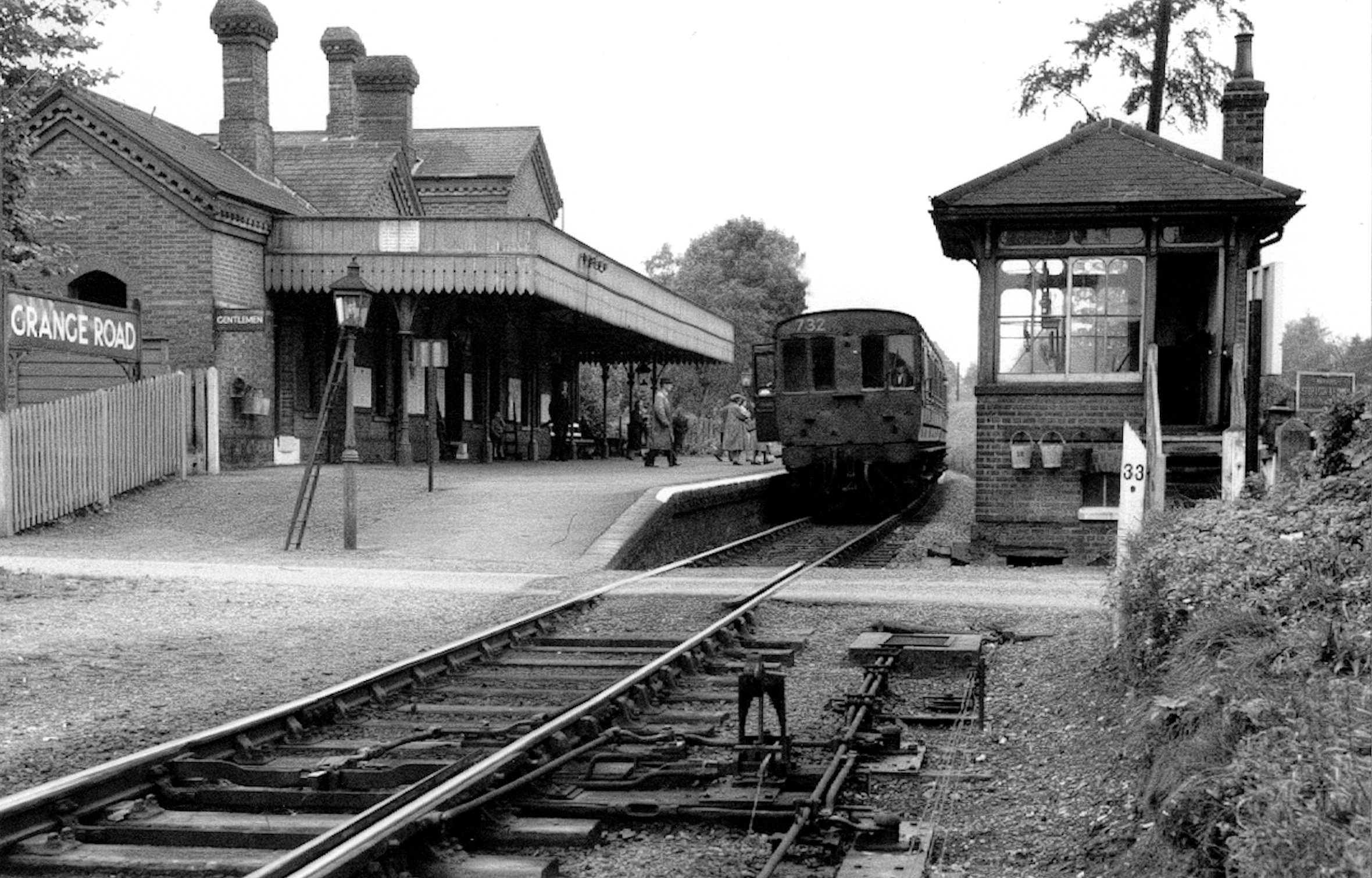
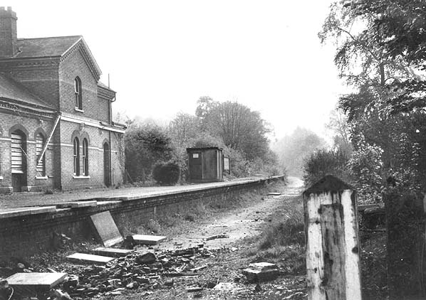
Grange Road railway station
The most significant presence in the 1950s village was the railway with Grange Road station, a signal box and level crossing. The single-track line saw goods and passenger services between Three Bridges and Tunbridge Wells via East Grinstead. Where Auchinleck Court is now, there was a siding that used to serve the brickworks. Scrub land, once the site of other brickworks, lay behind Bowers Place.
The first post-war developments were Buckley Place, built by Cuckfield Rural District Council on what had been part of Vicarage Farm, and Ruffwood, a small, select group of houses in a close off the Turners Hill Road. That was followed by Grange Crescent and the completion of Sunny Avenue. The old brickworks site opposite the bottom of Grange Road became Kiln Road and Woodlands Close towards the end of the 1950s. This growing number of people living near the railway station, some of whom will have used the railway for a daily commute, prompted the need for three new shops – the present Co-op, Flanagan’s and The Pantry/hairdresser – that were built next to the signal box in the early 1960s. The rest of the old Vicarage Farm land was next, becoming Squires Close, and Hazelwood Close next to Ruffwood. And not long after, Beech Holme and Beech Gardens were built on land north of the allotments.
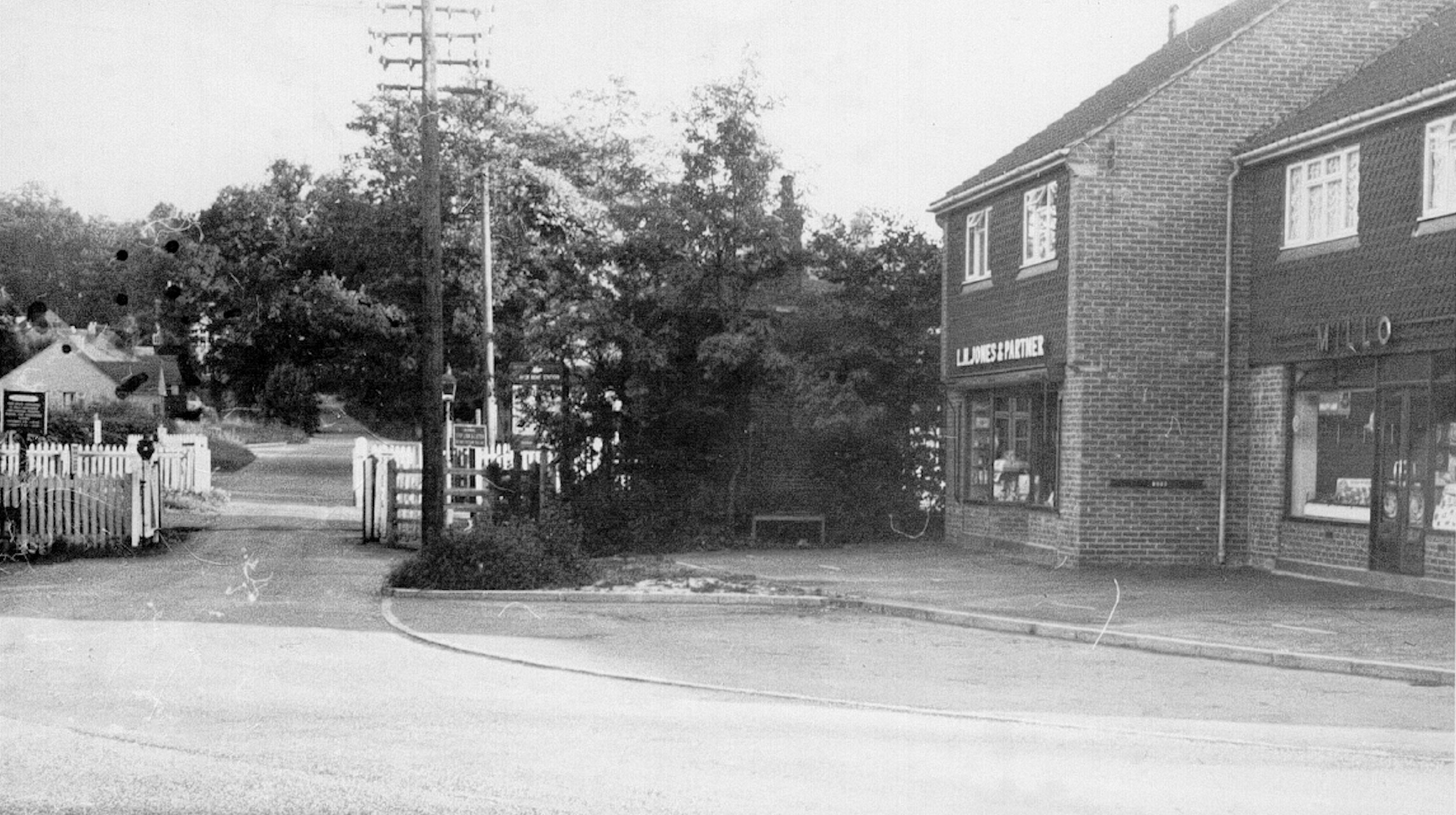
The level crossing and the new shops built in the early 1960s
The closure of the railway line at the beginning of 1967 looked likely to stagnate Crawley Down. Ironically the line from Grange Road station to Three Bridges was still viable but Dr Beeching’s plans to close uneconomical lines looked at the whole route from Tunbridge Wells so the only part that was retained briefly was the stretch from the old wartime fuel depot at Rowfant to Three Bridges. Within a short time the track had been taken up and the Victorian station, that dated back to 1874, had been demolished.
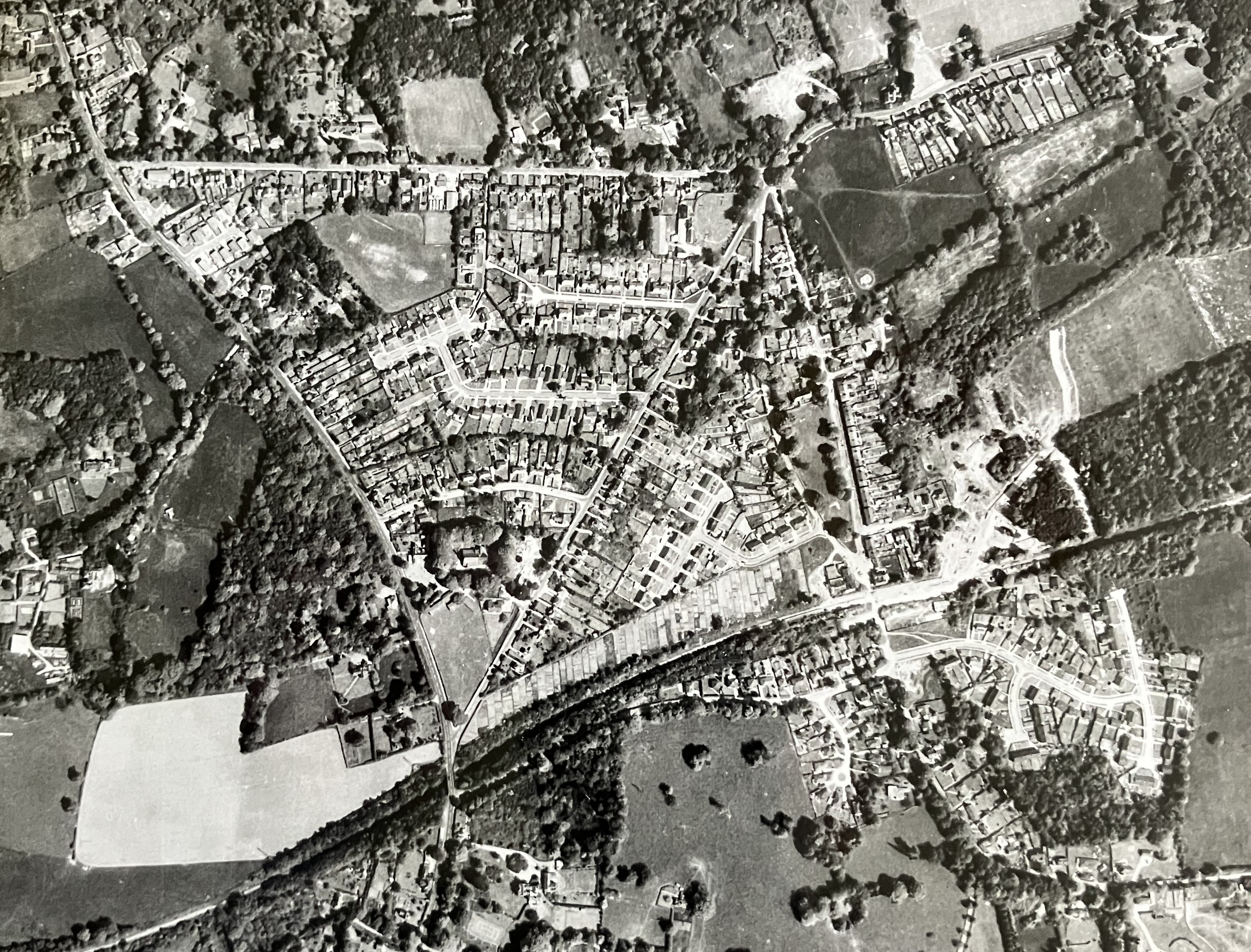
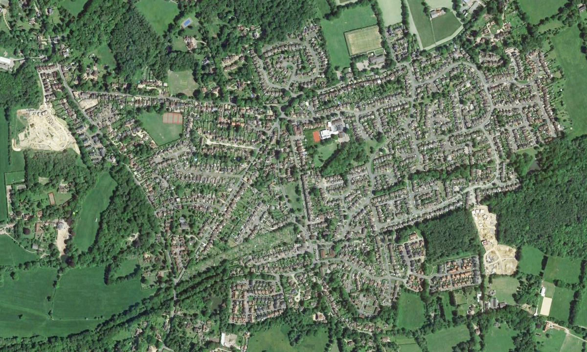
Aerial photo of Crawley Down in the early 1970s, showing the first work starting on the Burleighwood development (just above the railway line east of Bowers Place)
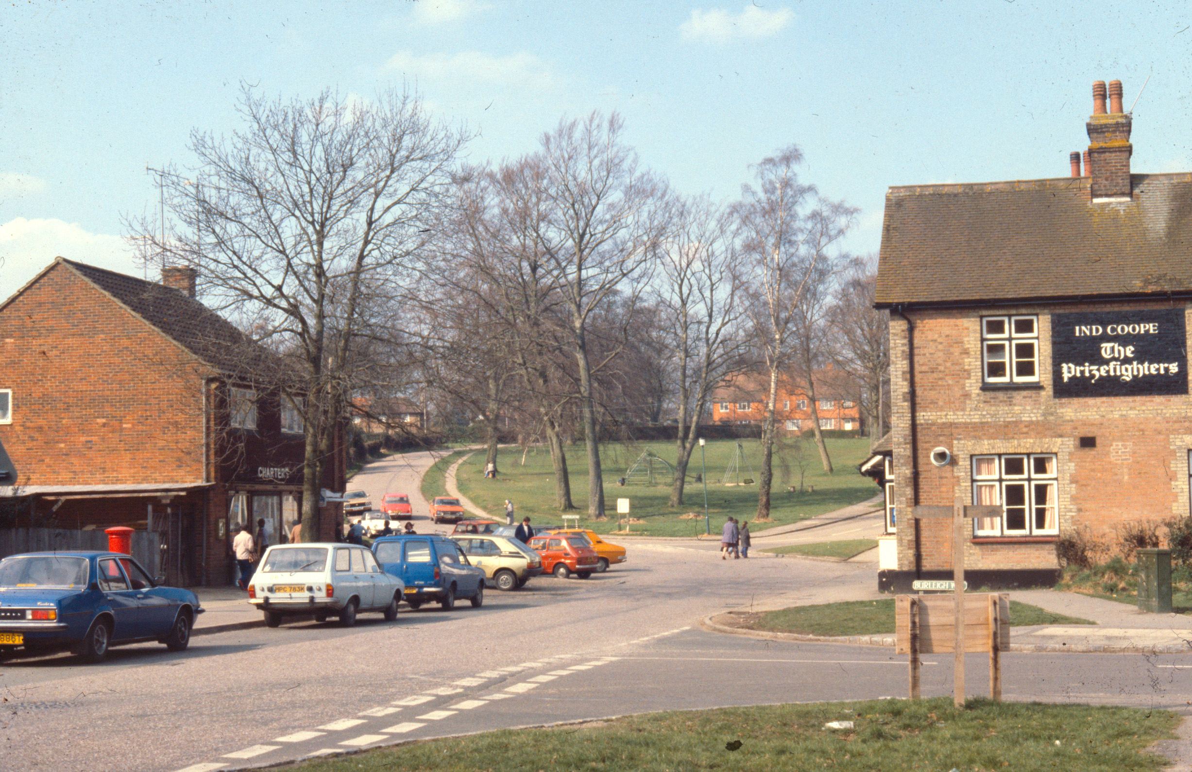
The sale of the old brickworks land east of Bowers Place and of the railway line to the south of it in the early 1970s led to the biggest change in Crawley Down since the village had begun to grow in the 1860s. The gradual construction of the Burleighwood Estate of over 800 houses over the next 10 years resulted in other changes as well: a new First School (Burleigh); a Health Centre , the previous surgery having been in a house in Hophurst Lane (seeThe History of Crawley Down Health Centre); more shops where the station had been; and the removal of the Post Office to what had become the centre of the village. Even the Royal Oak, which had started life as the Railway Hotel in 1866, was revamped and renamed The Prizefighters, ostensibly commemorating the sport of which Crawley Down had been a famous venue during the Regency period (seePrize Fighting), but which somewhat inappropriately displayed mementoes of the career of the 1940s boxer Freddie Mills.
The Prizefighters public house, the shops opposite and the Village Green in the 1970s
In 1974, local authority reorganisation caused Cuckfield Rural District and, with it, Crawley Down to be transferred to the county of West Sussex and become the new Mid-Sussex District. Notwithstanding that, the expansion of the village led to three other small developments at the time, notably the Fermandy Place estate, on land cleared after the demolition of a large house that had been a private school, Crawley St Mary’s (see Lost Buildings of Crawley Down). Another was the land where the railway station had been, which became Old Station Close. The line itself to Three Bridges was designated a linear country park – Worth Way – so named after a competition in 1976 that was won by the Junior School’s pupils. Thirdly, the remainder of the old brickworks land behind Kiln Road was developed for social housing and appropriately named Bricklands.
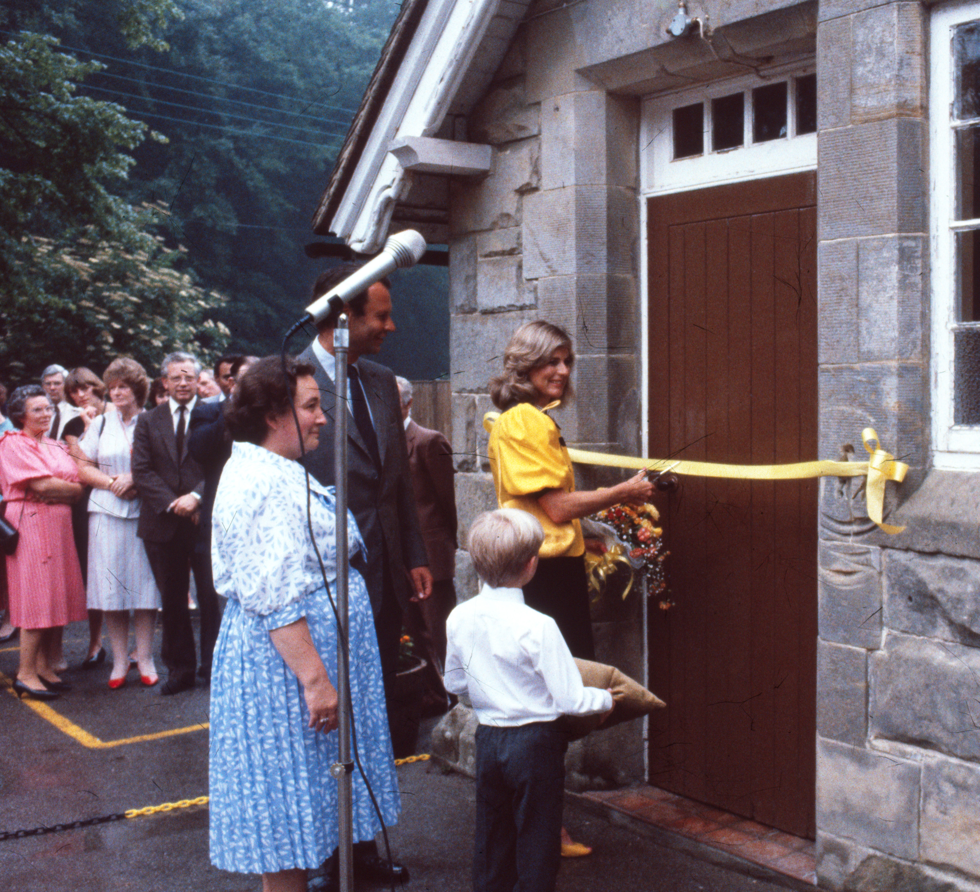
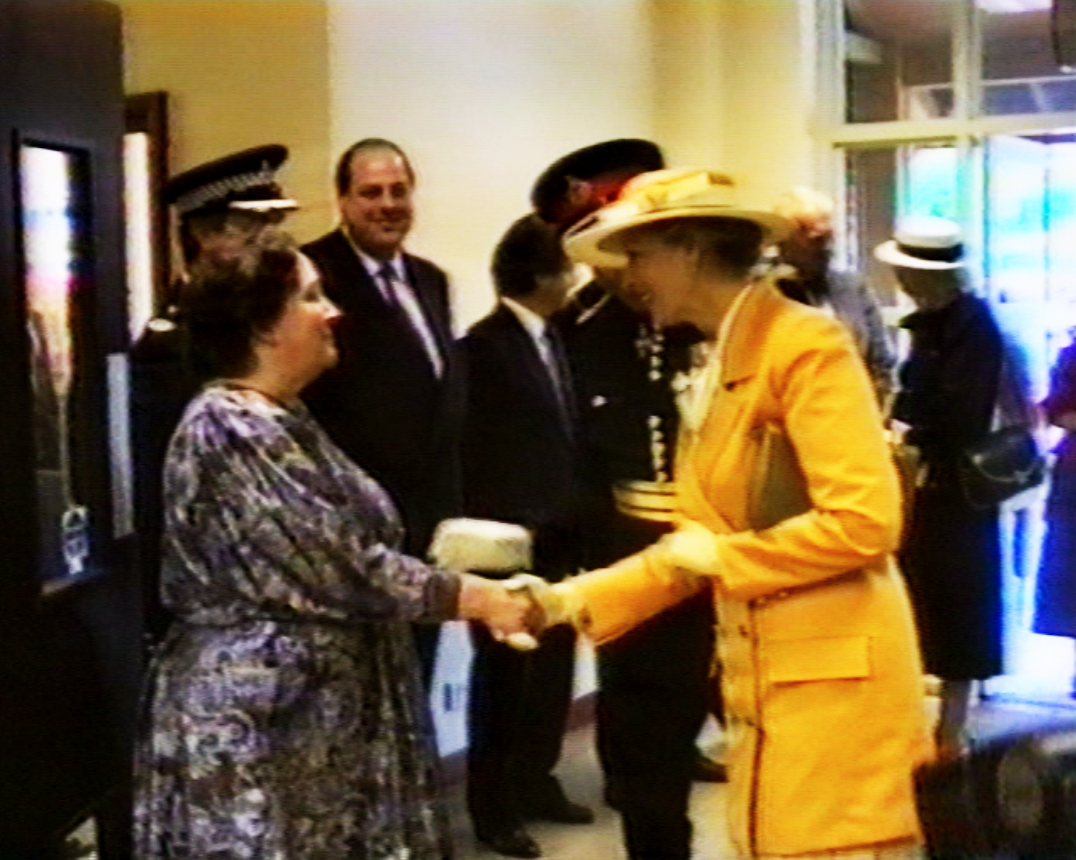
The Countess of Chichester cutting the ribbon to open the first community centre in the old school in 1986
When the Junior School was rebuilt next to Burleigh School and opened in 1981 the old school buildings became redundant, though not before the Earl of Chichester, whose ancestor had given them to the village back in 1851, claimed his right under the original deed of foundation to have them returned to him. West Sussex County Council came to a financial arrangement with the Earl which, in time, enabled him to support efforts in the village to build a community centre. The considerably increased village population meant that the Village Hall, which dated back to 1890, was no longer able to cope on its own with the increased demands for amenity space. So in 1986 the old school became a proto-community centre while funds were raised for a purpose-designed centre to occupy a corner of the Haven Sports Field, which had been created out of the old Haven Farm in the 1970s to provided extra village open space. The Haven Centre opened its doors in 1990, and was officially opened by HRH Princess Alexandra in June 1991.
Dorothy Hatswell, Chairman of the Crawley Down Community Centre Association, greeting Princess Alexandra at the opening of the Haven Centre, 24 June 1991 (from a video of the event)
Crawley Down has continued to grow since then. New parish rooms have been built next to the church, the Junior and Infant Schools merged in 2006 and have been enlarged, the Health Centre, too, has been enlarged. On the down side the Royal Oak, in its revived form, now lies unoccupied. More houses have been built, on land in front of the Grange and on the north side of Hophurst Lane in 2012, on the west side of the Turners Hill Road from 2014 (and continuing) and, from about the same time, in the south-east of the village behind Woodlands Close and Hazel Way. If the fact that between 1921 and 1931 the population of Crawley Down had grown from 1,021 to 1,134, in 1953 it was probably not much more than about 1,200. In the census of 2021 Crawley Down’s population was 5,774.
Aerial photo of Crawley Down in 2021, showing development of the village since the early-70s photo above
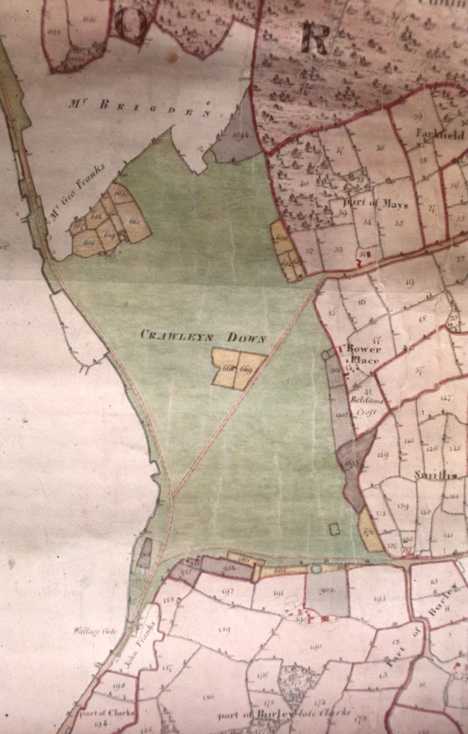
In the East Sussex Record Office at Brighton there is a large map of the properties held by the Manor of South Malling-Lindfield, a very ancient manor that dated back to Saxon times. The map, which was drawn by a surveyor named William Figg in 1829, and is orientated north-south, shows land belonging to the manor in the parishes of Worth, West Hoathly, Lindfield and Wivelsfield, in a continuous sheet at a scale of 1:47,520 (1 inch to 60 chains, if you are curious). Parcels of land are shown in four different colours, denoting the type of tenure: Red for freehold; Grey for leasehold; Yellow for copyhold; and Green for waste. Each parcel has a number which relates to a separate reference book. Below is the portion of the map showing Crawley Down.
In 1829 Crawley Down, which was sometimes called Crawleys Down or Crawley Downs, was manorial waste – a common. It had first been mentioned in historical documents back in 1274 and was probably waste then. It may have extended further to the north, the uncoloured area at the top of the map, and in 1829 owned by ‘Mr Brigden’ and by Mr George Franks, had evidently been purchased from the manor previously.
We can also see that several small parcels of land, coloured grey and yellow, had been enclosed from around the edges of the waste. The grey ones had been enclosed on long leases back in the 17th century, while the yellow ones were copyholds granted in the 30 or so years before the map was made. Copyholds were a sort of tenancy where the only proof was a copy of the roll of the manor court, and was surrendered when the tenant died. The location of the leaseholds suggests that they were acquired from the lord of the manor to increase the size of agricultural holdings around the edge of the waste, while the copyholds were probably ‘squatter’ enclosures where people had erected dwellings swiftly and then claimed retrospective permission from the lord to enclose land around them. Provided there were no local objections, the lord usually granted a tenancy and he could then claim a rent. In 1829 the lord of the manor was the earl of Chichester who lived at Stanmer Park near Brighton.
Squires Cottage
One such copyhold is shown in the middle of the waste with a dwelling on one of the parcels of land. This is Squires Cottage in what is now Squires Close. The Grange is shown to the south of Crawley Down, but not identified by name, even though it was so-called by the 1780s. On the east side of the waste, just south of Bower Place is the intriguingly-named ‘Beldams Croft’. A beldam was an old woman, a grandmother or, less respectfully, a witch or hag. I wonder which definition this piece of land relates to and when was it so-named. It is evidently part of the freehold of Bower Place farm so it is likely to be a field name of ancient origin. The earliest mention of the word in the Oxford Dictionary is from the 15th century. Down on the left side of the map, where the waste peters out, you should be just able to make out ‘Wallage Gate’. This was the toll-gate on the turnpike that ran from New Chapel (between East Grinstead and Blindley Heath) down to Brighton. William Cobbett (1763-1835), the journalist and social reformer, wrote in his Rural Rides (1822) that this road was ‘by far the pleasantest coach-road from the WEN to Brighton’. The WEN (i.e. a wart or tumour) was Cobbett’s sarcastic word for London. At the Wallage Gate, travellers on horseback or in waggons would have to pay a charge for the distance to the next toll-gate, like you do if you go over the Dartford Crossing or travel on French motorways. The gate was later moved to the top of Wallage Lane, and the turnpike was abandoned completely in the 1880s.
Apart from the turnpike, the only roads across the waste in 1829 were what is now Vicarage Road and one along the southern edge of Crawley Down which no longer exists. From the map we can get no indication of what vegetation there was. Was it heath, with furze, or gorse bushes, like Ashdown Forest, or was it wooded like the surviving remants of Copthorne Common? Presumably there would have been areas of grass as the tenants that lived close to the waste would have used it to graze animals, and I suspect that the universal need for wood for domestic heating and other uses would have meant that this patch of waste would have been largely devoid of mature trees.
In The Folklore of Sussex by Jacqueline Simpson (Batsford, 1973) an instance is recounted of Rough Music in Copthorne in the early 1950s. If you look up Rough Music in Wikipedia you will see the same instance referred to and discover that it was an expression of community displeasure when someone had outraged public decency. In this case, and in essence, a family was being ‘rough musicked’ because the father had hit the child of a neighbour. The case had been dismissed in court but the local people felt that the man had got away with it. On several successive Saturday nights the villagers paraded past the offender’s house banging cans and generally causing a lot of noise. Eventually the family at fault moved away.
Smuggler’s Cottage, Snow Hill; built in the 17th century (but made to look older)
Back in 1987 the late Patience Waller, then an elderly resident of Snow Hill, gave me her own account of an instance of Rough Music that she witnessed there in the early 1930s. Patience would have been a young teenager at the time. This is what she remembered:
“In the early 1930s the owner of Smuggler’s Cottage, Snow Hill had made himself very unpopular due to very unneighbourly behaviour towards three families living nearby.
He had an old gypsy living in one of his fields, & he employed this old man to cement up the overflow from the drainage system in one house, which if not discovered would have been very unpleasant.
Another neighbour, living at Goodwins, was having a hard tennis court made in her garden. She had obtained the Council’s permission to have the hard core, sand etc. delivered on to the side of the road for a few days before it was used. This however did not please Mr Raynor, & he employed his gypsy friend to scatter it all over the road in the night.
What really upset the village was his behaviour towards Miss East. She was a most delightful old lady, in her seventies, who looked after Mr Rowden, the tailor, who lived & worked in the house, now called ‘Tailors’.
A rough lane led to this cottage between high hedges, with a five-barred gate & a kissing gate and style to the footpath. The gate could be opened to allow deliveries to be made when necessary.
Mr Raynor decided that this gate should be padlocked, & he would not have it unlocked on any pretext. So next time Miss East needed coal, it had to be dumped on the side of the road & at the end of the lane. From there Miss East collected it scuttle by scuttle, a very lengthy and laborious business for an old lady.
Some of the locals decided this had gone too far & that Mr Raynor should learn just how unpopular he had made himself. They decided to give him Rough Music.
For three consecutive evenings about 50 people collected 100 yards from his house with every sort of old tin, saucepan, dustbin lid, or metal object, & they marched up & down outside his house banging anything they could get hold of for 20 minutes, & then threw all the utensils into his garden.
The Police put in an appearance but provided everyone kept on the move, & kept to the time limit there was no reason for them to interfere.
I cannot remember if it went on for 20 minutes or for one hour but I know that the timing was important. It had the desired effect & we had no more petty harassments from our unpopular neighbour.”
William Anthony Raynor had purchased Smuggler’s Cottage in about 1925. A tragic coda to this account appeared in the Daily Mirror of the 12th October 1940.
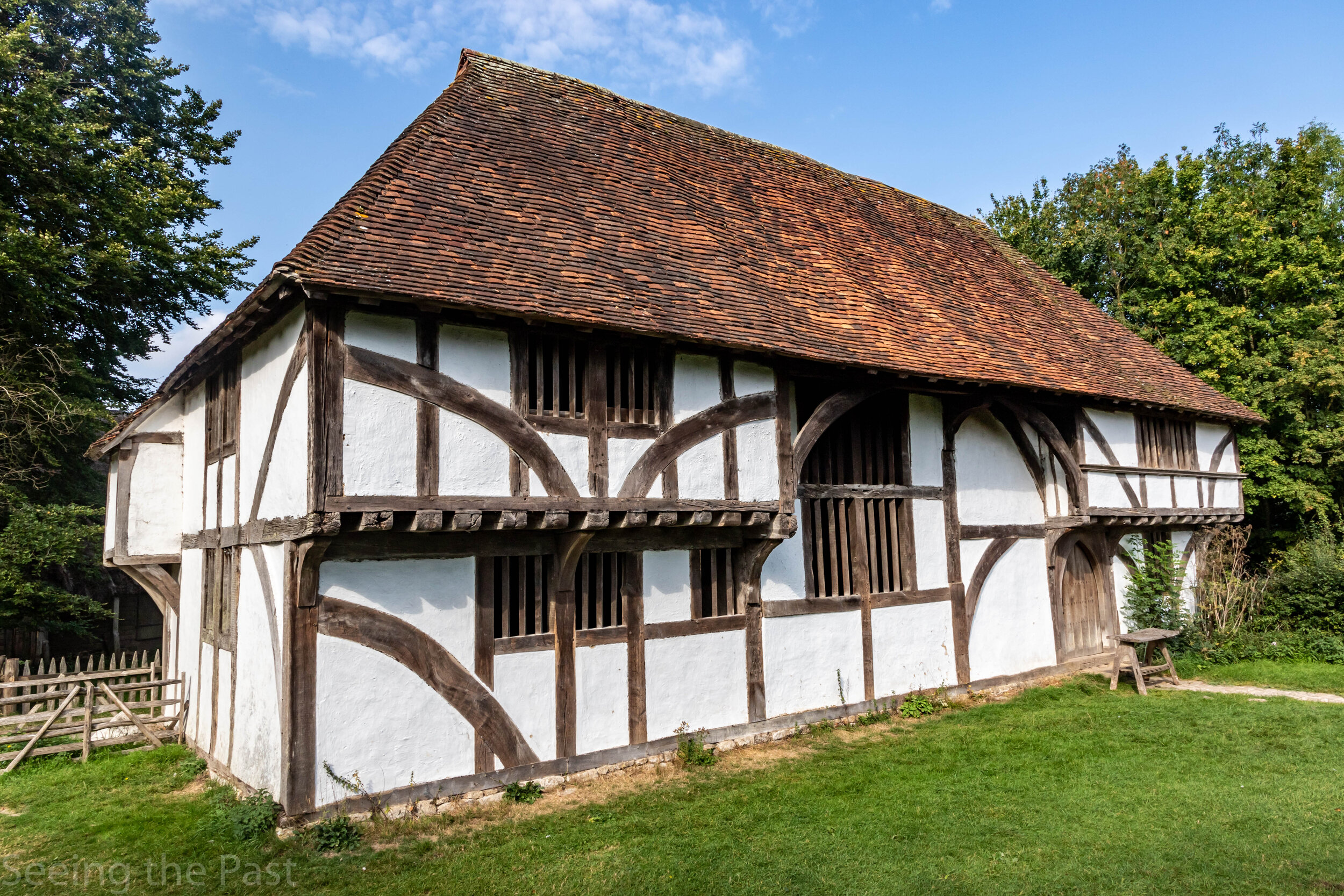
‘Bayleaf’ at the Weald and Downland Living History Museum,. Singleton
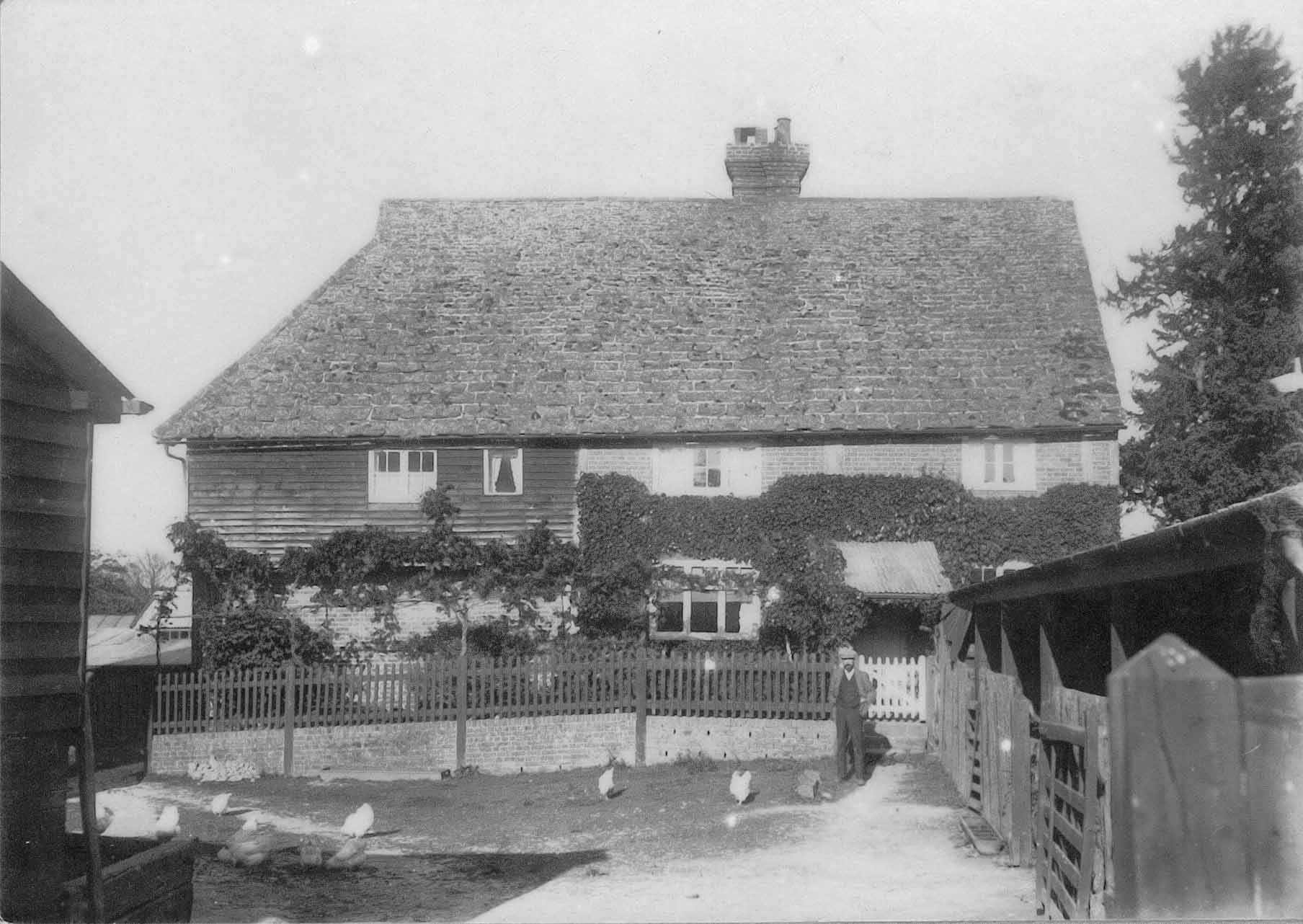
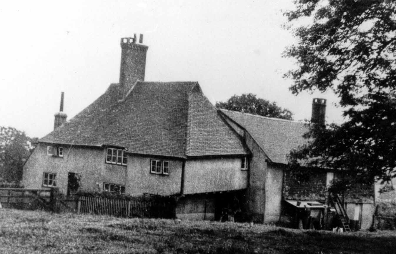
Sandhill, when it was still a working farm
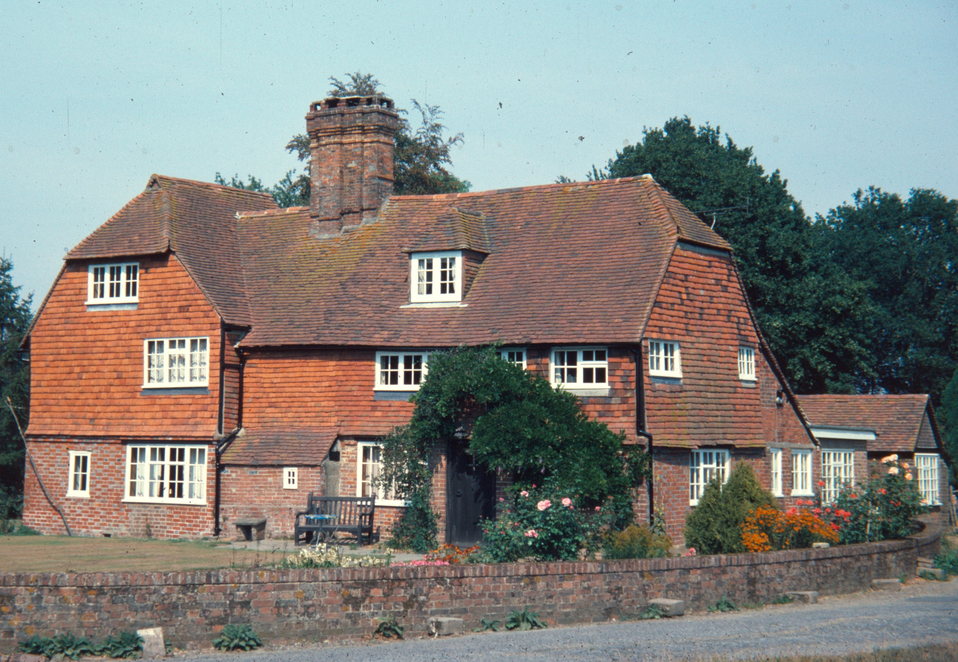
Although Crawley Down did not begin to develop as a village until the mid-19th century, there were several long-established farms in the area with farmhouses that, in some cases, date back to the Middle Ages. The oldest is Sandhill, which lies (no surprises) at the far end of Sandhill Lane. Recent dating by dendrochronology (measuring the tree rings of wooden beams) has shown that the trees used to build Sandhill were felled at the end of 1385, when Richard II was king, and the house was probably erected in the following year. It is what is known to students of vernacular architecture as a ‘Wealden’ hall house. That is to say it had a large central hall with no upper floor that was open to the rafters, and at each end two storeys with the upper floor jutting out, or ‘jettying’, on the front and ends of the house. If you have visited the Weald and Downland Living Museum at Singleton, north of Chichester (and it is well worth a visit) you will have seen a fine example of a ‘Wealden’ house called Bayleaf. Sandhill was just like it originally but at some time in the past the southern end of the house was destroyed, though from what cause is not known.
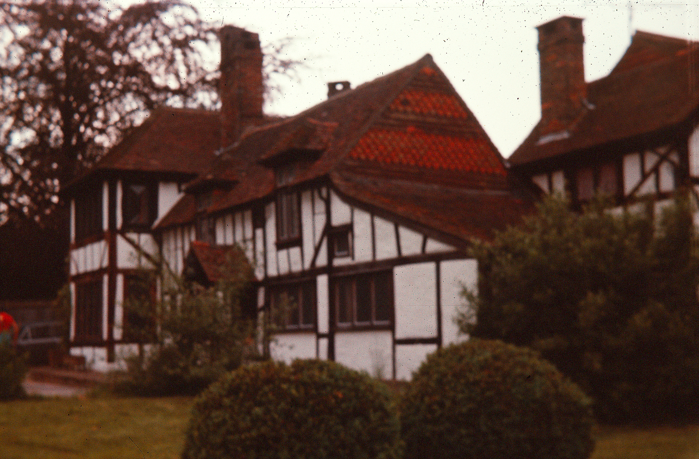
Burleigh House, as it was
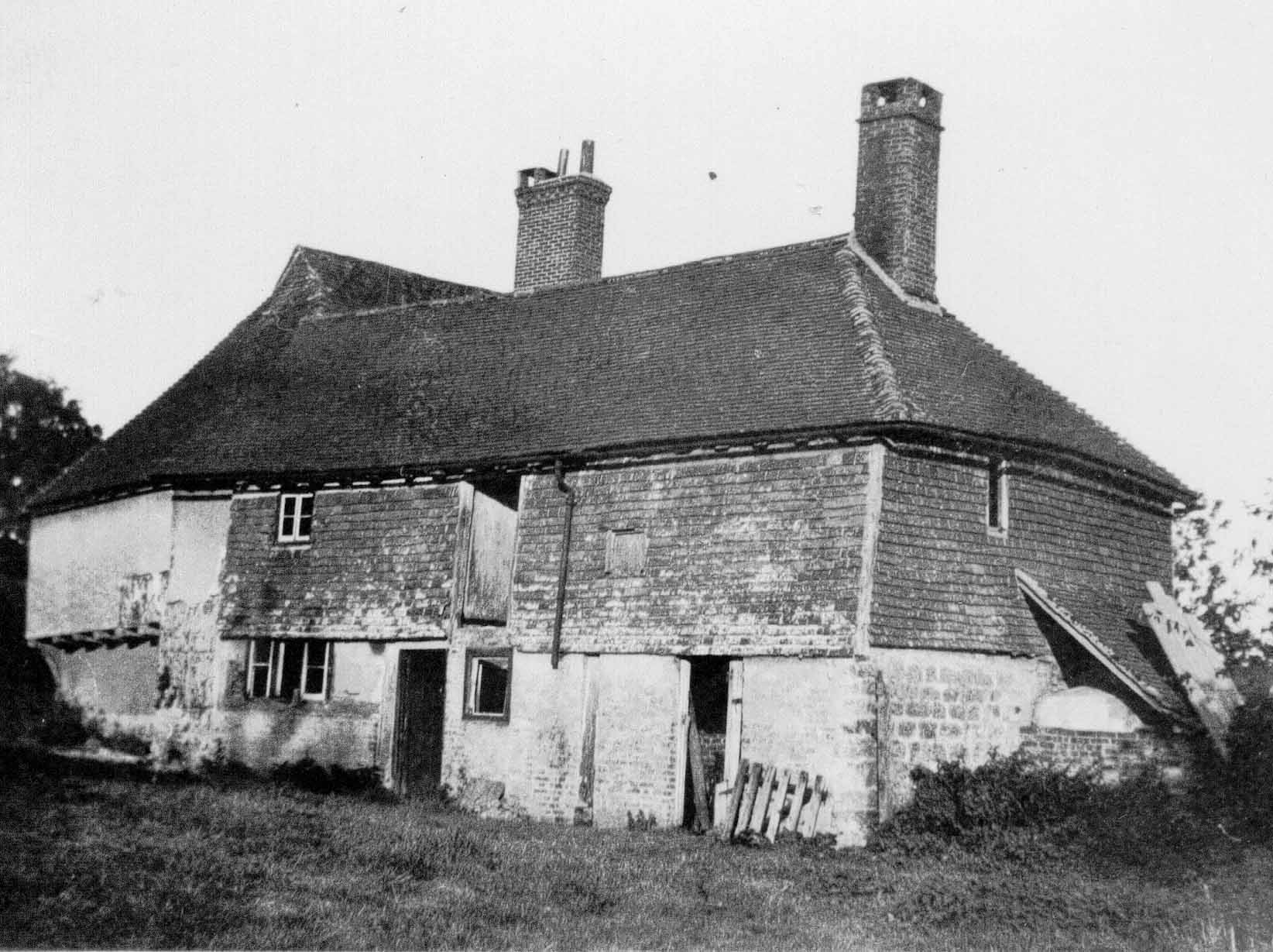
Burleigh House; the south wing (photo: R. T. Mason)
Burleigh House was another building of similar age and style. It stood at the end of Burleigh Lane, where there is a 20th century building in its place because in about 1936 the medieval house became unsafe and was demolished. A local historian, the late R. T. Mason, recorded the house in the pages of the now-defunct Sussex County Magazine, and years later he was kind enough to give me the photos he took of it. Typical of such buildings was the steep angled roof with the little ‘gablets’ at each end where the smoke from the hall fire would have escaped in the days before houses had chimneys. At some point in its later history a chimney was added and an extension to the house on its south side.
Hophurst farmhouse, c. 1980; the later wing is on the left
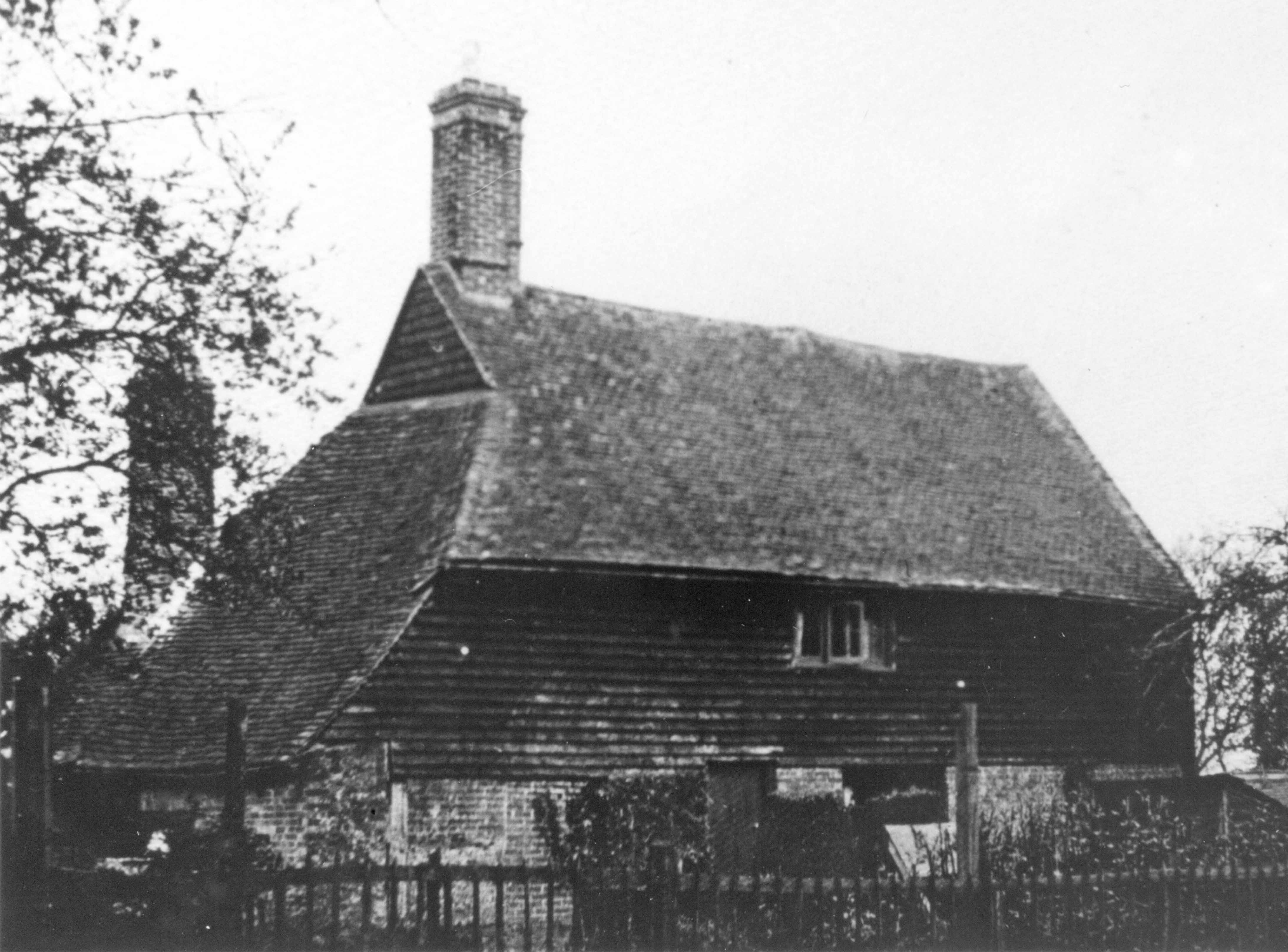
Hophurst farmhouse, near the corner where Hophurst Lane becomes Hophurst Hill, did not have a chimney either when it was first built in about 1530, but it did have a place for a fire at one end of the house, rather than in the middle of an open hall, and a separate section of the structure through which the smoke could rise. This was called a smoke bay and the evidence for it – soot encrusted rafters – was seen in 1979 when children from the Junior School undertook a project to study the history of the farm. Probably at the end of the Tudor period, and as with Burleigh House, a wing was added, this time at the north end of the house, and a brick chimney inserted between the older and newer parts.
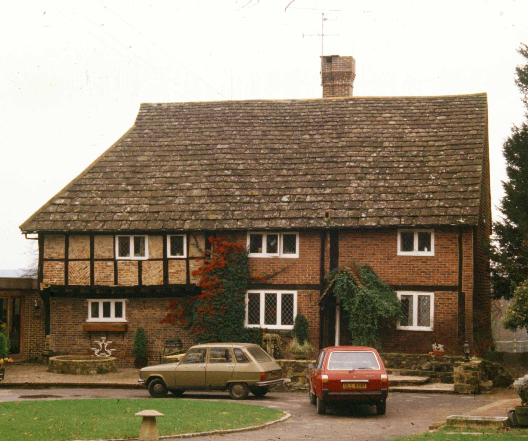
Sandhill Gate farmhouse, now Burleigh Cottage
At about the same time that Hophurst farmhouse was extended Sandhill Gate farmhouse was built. Now called Burleigh Cottage, at the junction of Sandhill and Burleigh Lanes, it took its original name from the fact that it stood by the gate that gave access from Sandhill onto the south-east corner of Crawley Down, then a stretch of common land. Those with appropriate rights could graze their animals on the Down and the gate prevented them from straying. There is a reference in the churchwarden’s accounts of Worth parish in 1599 to a meeting ‘at the house of John Nicholas at Sandhill Gate’.
In 1974 a short series of articles appeared in the All Saints’ church parish magazine. They were the recollections of an old lady who, as a girl, had grown up in Crawley Down. Her name was Annie Smith and she had been born, the daughter of Edward and Amelia Smith, at their home on Copthorne Common in May 1850. By the time Annie was old enough to remember, the family had moved into a small cottage which used to stand in the south-west corner of the junction of the Turners Hill Road and Wallage Lane. At that place there were gates across both roads because the Turners Hill Road was a turnpike, established in 1770, and tolls were levied on users of the road at strategic points along its route to pay for its upkeep. A condition on the Smith family’s occupation of the cottage was that they were responsible for collecting the tolls, and that role fell to Annie’s mother. Her father was employed as a gardener at Rowfant House, in those days the home of Sir Curtis and Lady Lampson.
Opposite the toll cottage was the Wallage, then a farm. In the census of 1851 it was also a beer shop and was the home of Annie’s grandfather and grandmother, Edward and Elizabeth Smith. Edward was the Parish Road Surveyor, so it was Elizabeth who sold the beer, assisted by her 14-year-old namesake daughter. The job of the parish surveyor was to maintain the condition of the roads, filling in potholes and clearing ditches to keep the roads from flooding. Annie recalled coaches passing their house on the way between London and Brighton before the opening of the railway station at Grange Road in 1860.
The headline from the Sussex Advertiser of 7th August 1855
It was the railway that resulted in tragedy for the Smith family, for on Monday 30th July 1855 Annie’s grandfather was fatally injured at Three Bridges station. The Sussex Advertiser reported on the inquest held at Brighton the following week. He and some of his men had been at the station unloading some flints and he had paused to watch the London-bound express come past, but had stepped back onto the line and failed to notice an approaching goods train shunting some wagons. The engine driver could not see Smith who was hit in the back by the engine’s buffer knocking him under the wheels. Despite desperate efforts by the railway staff a doctor could not be found, even along the line in Crawley, so the station master, Mr Savage, put on a train specially to take Smith to the County Hospital in Brighton, but he died of his injuries on the way, between Burgess Hill and Hassocks. Edward Smith was buried at All Saints’ church on the 2nd of August.
Annie Smith attended the village school, which had only opened in 1852. She recalled the master’s name as being ‘Mr Horsen’. This was, in fact, James Hallson who had been appointed, aged 38, in 1859. He was assisted by his wife, Martha, who taught the girls. They and their growing family lived in the school house, which was provided for them rent free.
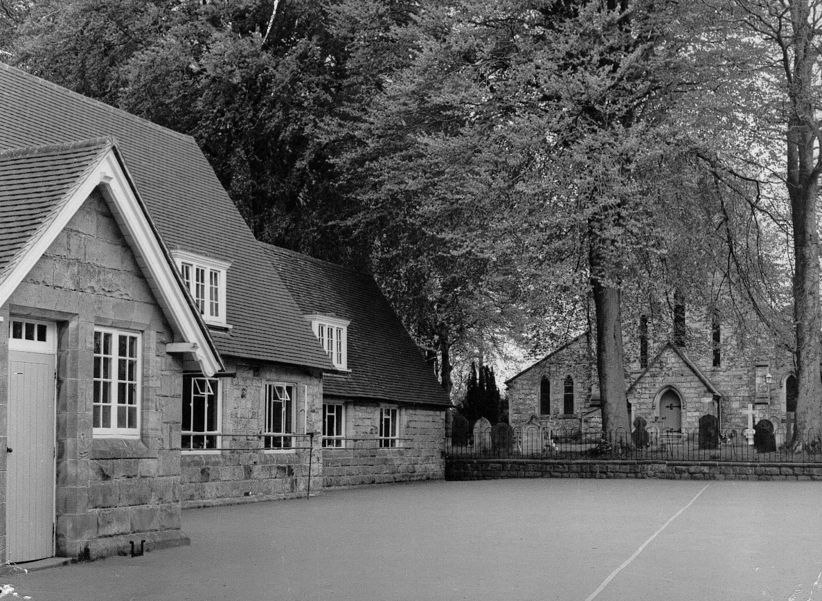
The school house and the original schoolroom, built in 1851
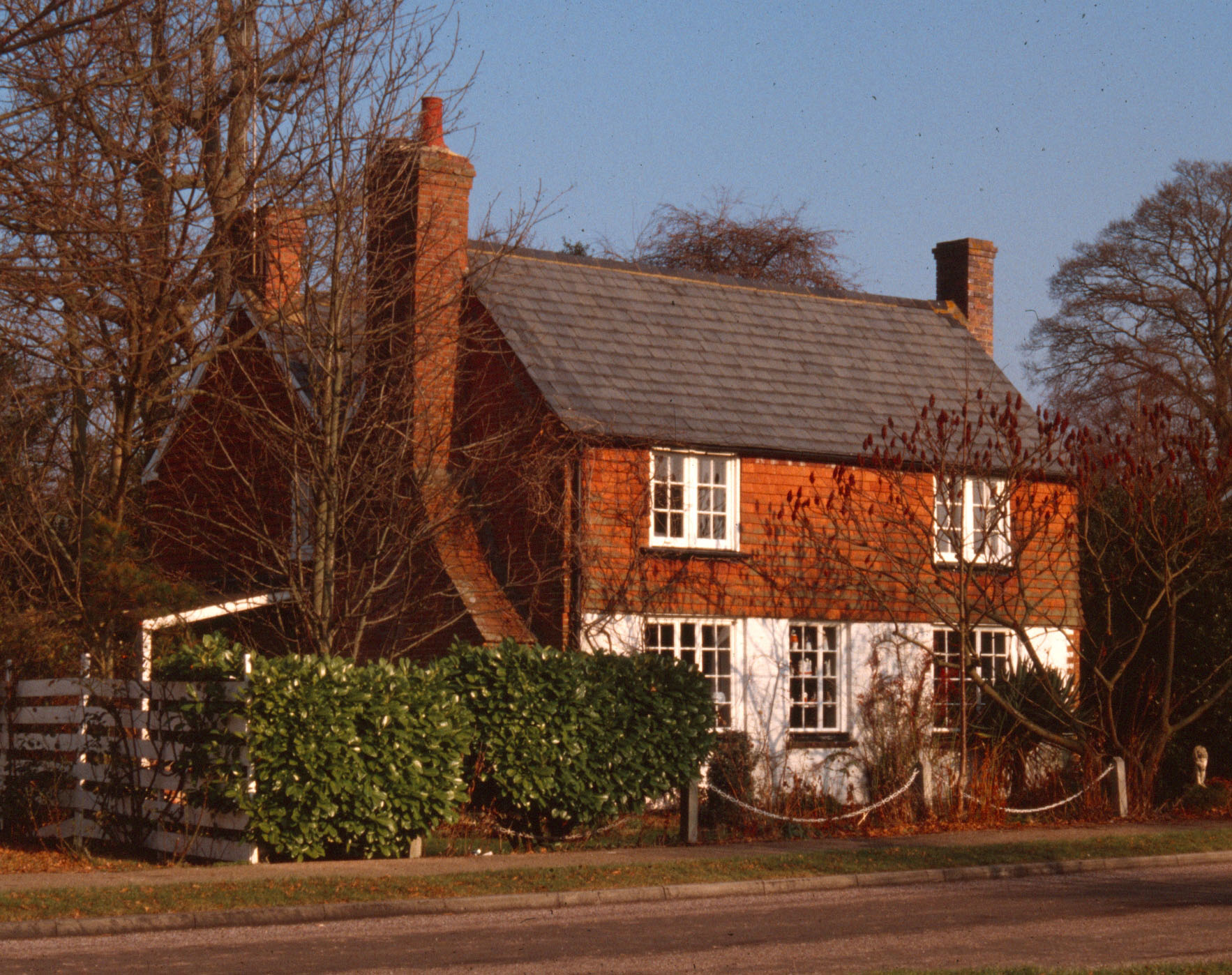
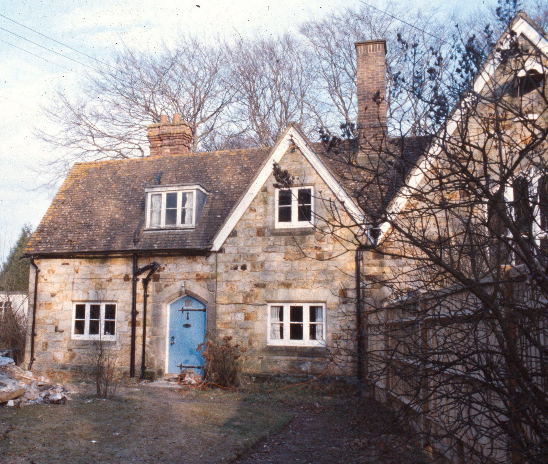
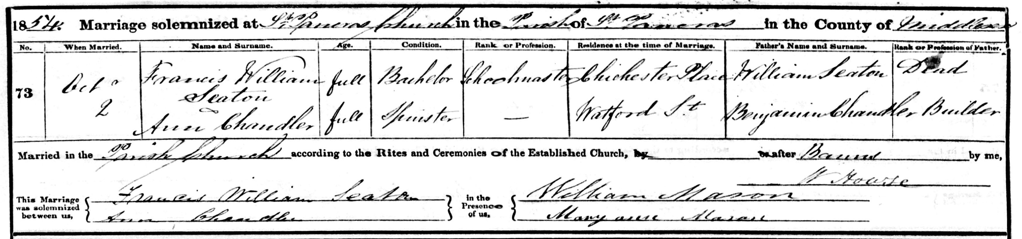
However, Annie would probably have started there when Mr Hallson’s predecessor had been in post. He was Francis Seaton and he was assisted in his role, initially, by his half-sister Martha Sheard. This arrangement did not last for long, though, for in 1854 Francis married Ann Chandler, the eldest daughter of the local builder, grocer and post-master, Benjamin Chandler, whose self-built house still stands on the west side of the Turners Hill Road just south of the railway bridge. Set into the brickwork at the front is a stone on which are his initials BC and the date 1834. Clearly, Francis Seaton’s tenure as master was short, and by 1861 his wife was a widow and had returned to live with her parents. Ann remarried at All Saints’ in March 1863 to Alfred Colven and went to live in Camberwell, but in a little over two years she too had died, aged only 35.
The register entry of Francis Seaton and Ann Chandler’s marriage at St Pancras church, London. Seaton’s name is incorrectly entered; his middle name was Wilson not WilliamThe house that Benjamin Chandler built in 1834. The roof has been altered since this photograph was taken in about 1905